IMAGES TAKEN NEAR TO
Harefield, SUDBURY, CO10 9DE
Introduction
This page details the photographs taken nearby to Harefield, CO10 9DE by members of the Geograph project.
The Geograph project started in 2005 with the aim of publishing, organising and preserving representative images for every square kilometre of Great Britain, Ireland and the Isle of Man.

There are currently over 7.5m images from over14,400 individuals and you can help contribute to the project by visiting https://www.geograph.org.uk
Image Map
Images are licensed for reuse under creativecommons.org/licenses/by-sa/2.0
Notes
- Clicking on the map will re-center to the selected point.
- The higher the marker number, the further away the image location is from the centre of the postcode.
Image Listing (45 Images Found)
Images are licensed for reuse under creativecommons.org/licenses/by-sa/2.0
Image
Details
Distance
2
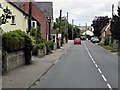
![Long Melford houses [8]](https://s0.geograph.org.uk/geophotos/06/73/80/6738080_eeeae91d_120x120.jpg)
Long Melford houses [8]
Hill House, High Street, is an early 19th century house. Covered in an ugly roughcast. Listed, grade II, with details at: https://historicengland.org.uk/listing/the-list/list-entry/1033669
Long Melford is a large village in Suffolk near the border with Essex, some 3 miles north of Sudbury. The village gained its name because it stretches for two and three quarter miles essentially along a single road. There is evidence of occupation from every period from the Mesolithic. The village contains two stately homes, Kentwell Hall and Melford Hall, is home to one of the largest and richest "wool churches" in East Anglia with fine flushwork, and a superb almshouse founded in 1573.
Image: © Michael Dibb
Taken: 12 Sep 2020
0.09 miles
3
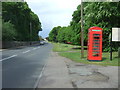
Telephone box on High Street, Long Melford
Outside the Hare Inn public house.
Image: © JThomas
Taken: 20 May 2017
0.11 miles
4
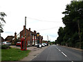
A1092 High Street & The Hare Inn Public House
Image: © Geographer
Taken: 14 Jun 2014
0.11 miles
5
![Long Melford houses [7]](https://s0.geograph.org.uk/geophotos/06/73/80/6738072_b8827c1d_120x120.jpg)
Long Melford houses [7]
Numbers 57 to 60 High Street are a range of 18th or 19th century timber framed and stuccoed houses. Extended on the right but with a lower roof. Listed, grade II, with details at: https://historicengland.org.uk/listing/the-list/list-entry/1033671
Long Melford is a large village in Suffolk near the border with Essex, some 3 miles north of Sudbury. The village gained its name because it stretches for two and three quarter miles essentially along a single road. There is evidence of occupation from every period from the Mesolithic. The village contains two stately homes, Kentwell Hall and Melford Hall, is home to one of the largest and richest "wool churches" in East Anglia with fine flushwork, and a superb almshouse founded in 1573.
Image: © Michael Dibb
Taken: 12 Sep 2020
0.11 miles
8
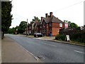
A1092 High Street & The Hare Inn Public House
At the entrance to Cherry Lane Garden Centre
http://www.hareinn.com/
http://www.cherry-lane.co.uk/home.asp
Image: © Geographer
Taken: 22 May 2014
0.11 miles
9
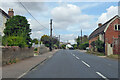
A1092 High Street, Long Melford
The smaller part of Long Melford north of Melford Park.
Image: © Robin Webster
Taken: 21 Aug 2022
0.11 miles
10
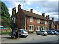
![Long Melford buildings [1]](https://s2.geograph.org.uk/geophotos/06/73/80/6738082_f2dbbd0b_120x120.jpg)
Long Melford buildings [1]
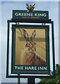
The Hare Inn, High Street, is a timber framed building probably from the 17th century. Refronted in red brick with stucco quoins in the late 18th or early 19th century. Listed, grade II, with details at: https://historicengland.org.uk/listing/the-list/list-entry/1033668
Long Melford is a large village in Suffolk near the border with Essex, some 3 miles north of Sudbury. The village gained its name because it stretches for two and three quarter miles essentially along a single road. There is evidence of occupation from every period from the Mesolithic. The village contains two stately homes, Kentwell Hall and Melford Hall, is home to one of the largest and richest "wool churches" in East Anglia with fine flushwork, and a superb almshouse founded in 1573.
Image: © Michael Dibb
Taken: 12 Sep 2020
0.12 miles