IMAGES TAKEN NEAR TO
Alpheton, SUDBURY, CO10 9BN
Introduction
This page details the photographs taken nearby to CO10 9BN by members of the Geograph project.
The Geograph project started in 2005 with the aim of publishing, organising and preserving representative images for every square kilometre of Great Britain, Ireland and the Isle of Man.

There are currently over 7.5m images from over14,400 individuals and you can help contribute to the project by visiting https://www.geograph.org.uk
Image Map
Images are licensed for reuse under creativecommons.org/licenses/by-sa/2.0
Notes
- Clicking on the map will re-center to the selected point.
- The higher the marker number, the further away the image location is from the centre of the postcode.
Image Listing (7 Images Found)
Images are licensed for reuse under creativecommons.org/licenses/by-sa/2.0
Image
Details
Distance
1
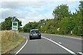
A134 looking north
A route from Colchester to King's Lynn, next major place, Bury St Edmunds. A 30 limit applies here for Alpheton.
Image: © Robin Webster
Taken: 21 Aug 2022
0.06 miles
2
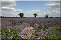
Borage
A large field at Alpheton planted with borage (also known as starflower, or common bugloss). Its seed is harvested in the Autumn and the oil is mainly used by the pharmaceutical industry.
Image: © Bob Jones
Taken: 8 Jul 2006
0.12 miles
3
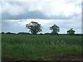
Oilseed rape crop, Melford Park
East of the A134.
Image: © JThomas
Taken: 20 May 2017
0.15 miles
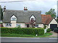
6
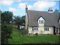
Cottage opposite Church Lane in Alpheton
Image: © John Firth
Taken: 17 Sep 2010
0.17 miles
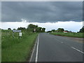
7
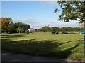
Looking across to the A134 from Church Lane in Alpheton
Image: © Robert Edwards
Taken: 12 Oct 2010
0.24 miles