IMAGES TAKEN NEAR TO
Lower Street, SUDBURY, CO10 9AJ
Introduction
This page details the photographs taken nearby to Lower Street, CO10 9AJ by members of the Geograph project.
The Geograph project started in 2005 with the aim of publishing, organising and preserving representative images for every square kilometre of Great Britain, Ireland and the Isle of Man.

There are currently over 7.5m images from over14,400 individuals and you can help contribute to the project by visiting https://www.geograph.org.uk
Image Map
Images are licensed for reuse under creativecommons.org/licenses/by-sa/2.0
Notes
- Clicking on the map will re-center to the selected point.
- The higher the marker number, the further away the image location is from the centre of the postcode.
Image Listing (11 Images Found)
Images are licensed for reuse under creativecommons.org/licenses/by-sa/2.0
Image
Details
Distance
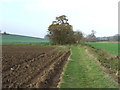
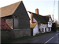
1
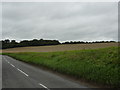
Calves Wood, Bar Wood and field of stubble
Image: © Peter Barr
Taken: 14 Sep 2010
0.06 miles
3
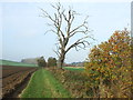
Dead Tree
Dead tree on the Stour Valley Path near to Stanstead, Suffolk.
Image: © Keith Evans
Taken: 17 Nov 2011
0.15 miles
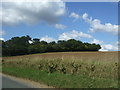
5
Footpath Junction
Footpath junction on the Stour Valley Path near to Stanstead, Suffolk.
Image: © Keith Evans
Taken: 17 Nov 2011
0.16 miles
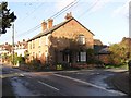
6
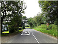
Entering Stanstead on the B1066 Lower Street
Image: © Geographer
Taken: 14 Jun 2014
0.17 miles
7
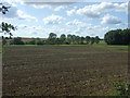
Flat field near the River Glem
View from Lower Street (B1066).
Image: © JThomas
Taken: 2 Sep 2017
0.17 miles
8
Entering Stanstead
Looking north west on Lower Street (B1066).
Image: © JThomas
Taken: 2 Sep 2017
0.17 miles
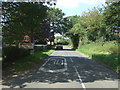
10
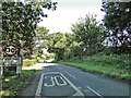
Speed restriction road markings and signage
Image: © Adrian S Pye
Taken: 28 Aug 2015
0.19 miles