IMAGES TAKEN NEAR TO
Boyton End, Stoke By Clare, SUDBURY, CO10 8TD
Introduction
This page details the photographs taken nearby to CO10 8TD by members of the Geograph project.
The Geograph project started in 2005 with the aim of publishing, organising and preserving representative images for every square kilometre of Great Britain, Ireland and the Isle of Man.

There are currently over 7.5m images from over14,400 individuals and you can help contribute to the project by visiting https://www.geograph.org.uk
Image Map
Images are licensed for reuse under creativecommons.org/licenses/by-sa/2.0
Notes
- Clicking on the map will re-center to the selected point.
- The higher the marker number, the further away the image location is from the centre of the postcode.
Image Listing (7 Images Found)
Images are licensed for reuse under creativecommons.org/licenses/by-sa/2.0
Image
Details
Distance
1
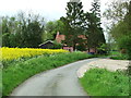
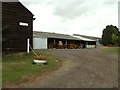
Field Lane Cottage
Field Lane Cottage on Way Ban Lane near to Wixoe, Essex.
Image: © Keith Evans
Taken: 10 May 2012
0.00 miles
2
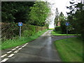
Start Of Way Bank Lane
The southern end of Way Bank Lane near to Wixoe, Essex.
Image: © Keith Evans
Taken: 10 May 2012
0.03 miles
3
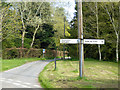
Way Back Lane
A public through route, but a proper road only as far as Crooks Hall. Beyond that a track which gets very overgrown towards its north end.
Image: © Robin Webster
Taken: 8 Apr 2017
0.04 miles
6
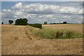
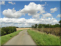
Farmland at Boyton End
Looking north from the minor road between Boyton End and Cain's Hill.
Image: © Bob Jones
Taken: 28 Jul 2007
0.21 miles
7
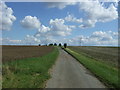
Cain's Hill
heading south east from Boyton End.
Image: © JThomas
Taken: 2 Sep 2017
0.23 miles