IMAGES TAKEN NEAR TO
Cavendish Road, SUDBURY, CO10 8PE
Introduction
This page details the photographs taken nearby to Cavendish Road, CO10 8PE by members of the Geograph project.
The Geograph project started in 2005 with the aim of publishing, organising and preserving representative images for every square kilometre of Great Britain, Ireland and the Isle of Man.

There are currently over 7.5m images from over14,400 individuals and you can help contribute to the project by visiting https://www.geograph.org.uk
Image Map
Images are licensed for reuse under creativecommons.org/licenses/by-sa/2.0
Notes
- Clicking on the map will re-center to the selected point.
- The higher the marker number, the further away the image location is from the centre of the postcode.
Image Listing (511 Images Found)
Images are licensed for reuse under creativecommons.org/licenses/by-sa/2.0
Image
Details
Distance
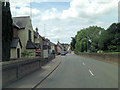
1
![Clare houses [3]](https://s3.geograph.org.uk/geophotos/06/75/44/6754411_74533de7_120x120.jpg)
Clare houses [3]
An 18th century timber framed and plaster house was extended in the 19th century and has recently been divided into two properties. The 18th century part is now Bareham House, number 34 Cavendish Road, and the 19th century part is Bareham Cottage. Listed, grade II, with details at: https://historicengland.org.uk/listing/the-list/list-entry/1031735
The market town of Clare is Suffolk’s smallest town. It lies on the north bank of the River Stour some 12 miles south of Bury St Edmunds and some 7 miles west of Sudbury. Remains of every period since the Palaeolithic have been found in the area. There is a Norman castle, a 13th century Augustinian Priory and a fine, medieval ‘wool’ church as well as many listed buildings, some of which date to the 16th century or earlier.
Image: © Michael Dibb
Taken: 14 Sep 2020
0.00 miles
2
![Clare houses [4]](https://s0.geograph.org.uk/geophotos/06/75/44/6754412_cbf16702_120x120.jpg)
Clare houses [4]
Number 33 Cavendish Road is late 18th or early 19th century, timber framed and plastered, now faced in roughcast. There is a carriage entrance on the right. Listed, grade II, with details at: https://historicengland.org.uk/listing/the-list/list-entry/1285657
The market town of Clare is Suffolk’s smallest town. It lies on the north bank of the River Stour some 12 miles south of Bury St Edmunds and some 7 miles west of Sudbury. Remains of every period since the Palaeolithic have been found in the area. There is a Norman castle, a 13th century Augustinian Priory and a fine, medieval ‘wool’ church as well as many listed buildings, some of which date to the 16th century or earlier.
Image: © Michael Dibb
Taken: 14 Sep 2020
0.01 miles
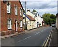
3
![Clare houses [5]](https://s2.geograph.org.uk/geophotos/06/75/44/6754414_bdd6f1eb_120x120.jpg)
Clare houses [5]
Numbers 30 and 31 Cavendish Road are a pair of 19th century brick cottages.
The market town of Clare is Suffolk’s smallest town. It lies on the north bank of the River Stour some 12 miles south of Bury St Edmunds and some 7 miles west of Sudbury. Remains of every period since the Palaeolithic have been found in the area. There is a Norman castle, a 13th century Augustinian Priory and a fine, medieval ‘wool’ church as well as many listed buildings, some of which date to the 16th century or earlier.
Image: © Michael Dibb
Taken: 14 Sep 2020
0.02 miles
5
Masonic Lodge
Masonic lodge number 1823 at Clare, Suffolk.
Image: © Keith Evans
Taken: 26 Oct 2011
0.02 miles
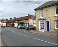
6
Cavendish Road (A1092), Clare
The old name for this road was Puddle Lane, although the Chilton (or Clare) stream which led to that name has been bridged for many centuries. Early in the 18c there was a turnpike at the bridge over the Chilton stream. This bridge was formerly called Pysenebregge, and in the 16th century was presumably a weighbridge with tolls. The C19 bricks of the house seen in the foreground (left) conceal a C16 house. It is one of the oldest houses in Clare in origin and one of the town's few stonehalls owned by the castle, perhaps to place soldiers in the town to control the populace. The owner in 1814 was John Jarvis, who owned a brickworks and re-fronted the house with his own distinctive bricks. He also built a forge along Cavendish Road (seen in the background). This information was taken from "A historical look at Clare" by David Hatton which is available on the Internet in pdf-format: http://www.clare-uk.com/pages/hatton-book-681.htm.
Clare is situated on the A1092 road, about 8 miles from Sudbury and 8 miles from Haverhill. Clare once was a border fortress town between the kingdom of the East Angles and the Saxons and its name is believed to be derived from the Roman word Clarus, meaning illustrious or renowned. Clare is mentioned in the Domesday Book as a settlement of 600 inhabitants, with extensive vineyards. The latter no longer exist but it is possible that Claret got its name from Clare. A castle was built after the Battle of Hastings in 1066 in order to protect the surrounding land and its ruined castle's stone keep > http://www.geograph.org.uk/photo/2072116 remains until today. It is situated on the edge of Clare Country Park > http://www.geograph.org.uk/photo/2072118 and can be accessed via a footpath around the motte. The Country Park also houses the disused Clare railway station > http://www.geograph.org.uk/photo/2072125 and a goods shed > http://www.geograph.org.uk/photo/2072119 which is now the park's visitor centre. Austian Friars arrived in the town in 1249 and were given land here. They built a Friars House and the church > http://www.geograph.org.uk/photo/2072712. The town has many historic houses > http://www.geograph.org.uk/photo/2072565 and buildings, with Clare Ancient House > http://www.geograph.org.uk/photo/2072752 being one of the oldest houses in Suffolk. It became the town museum in 1979 and is notable for its superb plasterwork which is an outstanding work of the local craft of pargetting > http://www.geograph.org.uk/photo/2072761 that is still practised today. This decorated plaster-work can be seen on a number of houses, much of it done on old timber-framed buildings. While the plaster is still wet it is either worked over with wooden combs to produce herringbone, shell and similar patterns or shapes are applied with moulds or sculpted by hand to create more individuality.
Image: © Evelyn Simak
Taken: 18 Sep 2010
0.02 miles
7
The Bell public house in Clare town centre
Clare is situated on the A1092 road, about 8 miles from Sudbury and 8 miles from Haverhill. Clare once was a border fortress town between the kingdom of the East Angles and the Saxons and its name is believed to be derived from the Roman word Clarus, meaning illustrious or renowned. Clare is mentioned in the Domesday Book as a settlement of 600 inhabitants, with extensive vineyards. The latter no longer exist but it is possible that Claret got its name from Clare. A castle was built after the Battle of Hastings in 1066 in order to protect the surrounding land and its ruined castle's stone keep > http://www.geograph.org.uk/photo/2072116 remains until today. It is situated on the edge of Clare Country Park > http://www.geograph.org.uk/photo/2072118 and can be accessed via a footpath around the motte. The Country Park also houses the disused Clare railway station > http://www.geograph.org.uk/photo/2072125 and a goods shed > http://www.geograph.org.uk/photo/2072119 which is now the park's visitor centre. Austian Friars arrived in the town in 1249 and were given land here. They built a Friars House and the church > http://www.geograph.org.uk/photo/2072712. The town has many historic houses > http://www.geograph.org.uk/photo/2072565 and buildings, with Clare Ancient House > http://www.geograph.org.uk/photo/2072752 being one of the oldest houses in Suffolk. It became the town museum in 1979 and is notable for its superb plasterwork which is an outstanding work of the local craft of pargetting > http://www.geograph.org.uk/photo/2072761 that is still practised today. This decorated plaster-work can be seen on a number of houses, much of it done on old timber-framed buildings. While the plaster is still wet it is either worked over with wooden combs to produce herringbone, shell and similar patterns or shapes are applied with moulds or sculpted by hand to create more individuality.
Image: © Evelyn Simak
Taken: 18 Sep 2010
0.03 miles
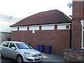
8
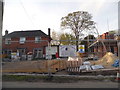
New house construction on Cavendish Street, Clare
Image: © David Howard
Taken: 18 Apr 2017
0.03 miles
9
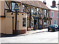
The Bell Hotel, Clare
The Bell Hotel, a 17th Century coaching Inn, showing half timbered facade and the turret. http://www.thebellhotel-clare.com
Image: © David Flory
Taken: 13 Sep 2003
0.04 miles
10
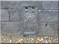
Ordnance Survey Flush Bracket 2052
This can be found on the roadside wall of The Bell Inn at Clare.
For more detail see : http://www.bench-marks.org.uk/bm1988
Image: © Peter Wood
Taken: 25 Feb 2015
0.04 miles