IMAGES TAKEN NEAR TO
Hundon Road, SUDBURY, CO10 8HZ
Introduction
This page details the photographs taken nearby to Hundon Road, CO10 8HZ by members of the Geograph project.
The Geograph project started in 2005 with the aim of publishing, organising and preserving representative images for every square kilometre of Great Britain, Ireland and the Isle of Man.

There are currently over 7.5m images from over14,400 individuals and you can help contribute to the project by visiting https://www.geograph.org.uk
Image Map
Images are licensed for reuse under creativecommons.org/licenses/by-sa/2.0
Notes
- Clicking on the map will re-center to the selected point.
- The higher the marker number, the further away the image location is from the centre of the postcode.
Image Listing (10 Images Found)
Images are licensed for reuse under creativecommons.org/licenses/by-sa/2.0
Image
Details
Distance
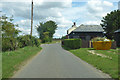
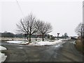
2
House at Road junction North of Stoke By Clare
House lies in fork of junction of A 1092 and minor road to Hundon
Image: © John Firth
Taken: 16 Sep 2010
0.09 miles
3
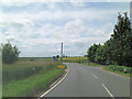
A1092 passes Three Ways
To the right is Maple Hill.
Image: © Stuart Logan
Taken: 28 Jun 2013
0.12 miles
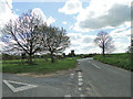
4
Road Junction
Road junction near to Stoke by Clare, Suffolk.
Image: © Keith Evans
Taken: 9 Feb 2012
0.12 miles
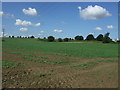
5
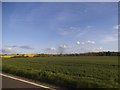
Field in Stoke by Clare
Next to Stoke Road
Image: © David Howard
Taken: 18 Apr 2017
0.13 miles
6
Three Ways, a road junction near Clare
Image: © Adrian S Pye
Taken: 27 Apr 2015
0.14 miles
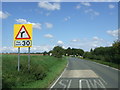
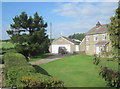
8

A junction near Stoke by Clare, Suffolk
This is where the road from Chilton Street meets the A.1092
Image: © Robert Edwards
Taken: 30 Oct 2006
0.17 miles
9
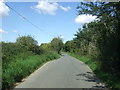
Minor road towards Hundon
Looking north near Cadhams Farm Bungalows.
Image: © JThomas
Taken: 2 Sep 2017
0.25 miles