IMAGES TAKEN NEAR TO
Patticroft, SUDBURY, CO10 7UJ
Introduction
This page details the photographs taken nearby to Patticroft, CO10 7UJ by members of the Geograph project.
The Geograph project started in 2005 with the aim of publishing, organising and preserving representative images for every square kilometre of Great Britain, Ireland and the Isle of Man.

There are currently over 7.5m images from over14,400 individuals and you can help contribute to the project by visiting https://www.geograph.org.uk
Image Map (Loading...)


Getting Data...Please wait
Leaflet Map data © OpenStreetMap
Images are licensed for reuse under creativecommons.org/licenses/by-sa/2.0
Notes
- Clicking on the map will re-center to the selected point.
- The higher the marker number, the further away the image location is from the centre of the postcode.
Image Listing (13 Images Found)
Images are licensed for reuse under creativecommons.org/licenses/by-sa/2.0
Image
Details
Distance
1
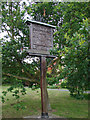
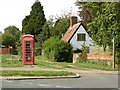
Brook Street village sign
Brook Street is a hamlet of Glemsford, The carved sign has and owl and a squirrel on the top line. In the centre panel is The Chequers, sadly no longer a public house, once obviously considered the centre of Brook Street. It is surrounded by six more panels containing other important buildings, businesses and historical features. https://www.geograph.org.uk/photo/6747216
Image: © Adrian S Pye
Taken: 17 Aug 2007
0.08 miles
2
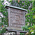
Brook Street village sign
Brook Street is a hamlet of Glemsford, The carved sign has and owl and a squirrel on the top line. In the centre panel is The Chequers, sadly no longer a public house, once obviously considered the centre of Brook Street. It is surrounded by six more panels containing other important buildings, businesses and historical features. https://www.geograph.org.uk/photo/4291527
Image: © Adrian S Pye
Taken: 11 Dec 2020
0.08 miles
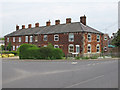
3
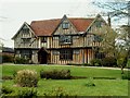
Chequers, Glemsford, Suffolk
This is one of the many old listed buildings that make up Glemsford. It is 17th century and originally a hall house.
Image: © Robert Edwards
Taken: 1 May 2006
0.11 miles
5
Public footpath in Glemsford
The footpath leads to Fern Hill.
Image: © Robert Edwards
Taken: 22 Sep 2010
0.14 miles
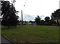
6

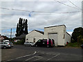
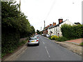
Brook Street, Glemsford
Looking towards the junction with the B1065 Broadway & B1065 Bells Lane
Image: © Geographer
Taken: 14 Jun 2014
0.15 miles
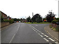
7
Brook Street Green & B1065 Broadway
Off Brook Street
Image: © Geographer
Taken: 14 Jun 2014
0.15 miles
9
B1065 Broadway, Glemsford
At the junction with Brook Street & B1065 Bells Lane
Image: © Geographer
Taken: 14 Jun 2014
0.17 miles
10
B1065 Bells Lane, Glemsford
At the junction with the B1065 Broadway & Brook Street
Image: © Geographer
Taken: 14 Jun 2014
0.17 miles