IMAGES TAKEN NEAR TO
St. Andrews Rise, SUDBURY, CO10 7TH
Introduction
This page details the photographs taken nearby to St. Andrews Rise, CO10 7TH by members of the Geograph project.
The Geograph project started in 2005 with the aim of publishing, organising and preserving representative images for every square kilometre of Great Britain, Ireland and the Isle of Man.

There are currently over 7.5m images from over14,400 individuals and you can help contribute to the project by visiting https://www.geograph.org.uk
Image Map
Images are licensed for reuse under creativecommons.org/licenses/by-sa/2.0
Notes
- Clicking on the map will re-center to the selected point.
- The higher the marker number, the further away the image location is from the centre of the postcode.
Image Listing (43 Images Found)
Images are licensed for reuse under creativecommons.org/licenses/by-sa/2.0
Image
Details
Distance
1
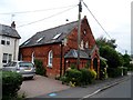
Former chapel, Bulmer
Still marked on the O.S. map as a chapel, but it is now converted to residential use.
Image: © Bikeboy
Taken: 29 May 2014
0.08 miles
2
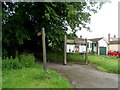
Entrance to Coe's Meadow, Bulmer
Coe's meadow is a public space which was bequeathed to the village by a former resident and local farmer, Lawrence Coe. The will was contested but the local parish won the case in 2002.
Image: © Bikeboy
Taken: 29 May 2014
0.09 miles
3
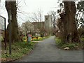
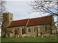
St. Andrew's church, Bulmer, Essex
A pleasant approach to the 14th century church at Bulmer.
Image: © Robert Edwards
Taken: 12 Apr 2006
0.10 miles
4

No right of way
No right of way sign near to Bulmer Essex.
Image: © Keith Evans
Taken: 9 Oct 2008
0.10 miles
5
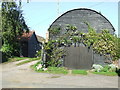
Old pump and shed
Old pump and shed on the main road through Bulmer Essex.
Image: © Keith Evans
Taken: 9 Oct 2008
0.11 miles
6
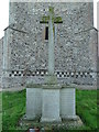
Bulmer War Memorial
The Memorial bears the 18 names of men who fell in WW1. There are two HARBORDs, three RAYMONDs, two SARGENTs, two WEAVERS and two WILLIS.
It is not yet known what relationship they were to each other.
There were also four men lost in WW2.
Image: © Adrian S Pye
Taken: 31 Aug 2017
0.11 miles
7
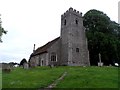
St Andrew's church, Bulmer
Possibly C12 origins but restored in C14, C15 and C19.
Image: © Bikeboy
Taken: 29 May 2014
0.11 miles
8
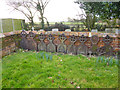
Cast-iron grave markers, Bulmer churchyard
All to a standard design except one. They seem to have had painted inscriptions, which unsurprisingly have not lasted. The standard design has on its reverse the name of the iron works, or at least the name of the marketer. I couldn't make this out, except it was in Sudbury.
Image: © Robin Webster
Taken: 1 Mar 2015
0.12 miles
9
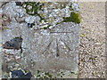
Ordnance Survey Cut Mark
This can be found on the wall of St Andrews Church in Bulmer.
For more detail see : http://www.bench-marks.org.uk/bm47154
Image: © Peter Wood
Taken: 21 Feb 2015
0.12 miles
10
The Church of St Andrew at Bulmer
Viewed from the south.
Image: © Peter Wood
Taken: 21 Feb 2015
0.12 miles