IMAGES TAKEN NEAR TO
Pitfield Green, SUDBURY, CO10 7NH
Introduction
This page details the photographs taken nearby to Pitfield Green, CO10 7NH by members of the Geograph project.
The Geograph project started in 2005 with the aim of publishing, organising and preserving representative images for every square kilometre of Great Britain, Ireland and the Isle of Man.

There are currently over 7.5m images from over14,400 individuals and you can help contribute to the project by visiting https://www.geograph.org.uk
Image Map (Loading...)


Getting Data...Please wait
Leaflet Map data © OpenStreetMap
Images are licensed for reuse under creativecommons.org/licenses/by-sa/2.0
Notes
- Clicking on the map will re-center to the selected point.
- The higher the marker number, the further away the image location is from the centre of the postcode.
Image Listing (23 Images Found)
Images are licensed for reuse under creativecommons.org/licenses/by-sa/2.0
Image
Details
Distance
1
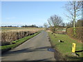
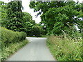
Country Road
Country road near to Little Henny, Essex.
Image: © Keith Evans
Taken: 23 Feb 2012
0.12 miles
2
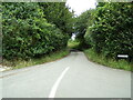
Amos Hill, Great Henny
At the junction with Watery Lane
Road No.U4033
Image: © Geographer
Taken: 7 Jul 2021
0.18 miles
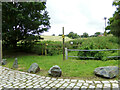
3
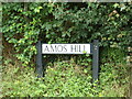
Amos Hill sign
On Amos Hill at the junction with Watery Lane
Road No.U4033
Image: © Geographer
Taken: 7 Jul 2021
0.18 miles
4
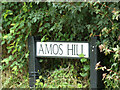
Amos Hill sign
On Amos Hill at the junction with Watery Lane
Road No.U4033
Image: © Geographer
Taken: 7 Jul 2021
0.18 miles
5

Watery Lane, Great Henny
At the junction with Amos Hill
Road No.U4031
Image: © Geographer
Taken: 7 Jul 2021
0.19 miles
6
Watery Lane, Great Henny
At the junction with Amos Hill
Road No.U4031
Image: © Geographer
Taken: 7 Jul 2021
0.19 miles
7

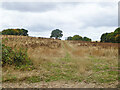
Looking over wheat field to small wood, Great Henny
Image: © Roger Jones
Taken: 5 Jun 2016
0.19 miles
8
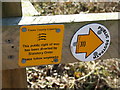
Footpath Sign
Footpath sign seen near to Little Henny, Essex.
Image: © Keith Evans
Taken: 23 Feb 2012
0.19 miles
9
Footpath to Church Road
Off Watery Lane at the junction with Amos Hill
Great Henny footpath No.20
Image: © Geographer
Taken: 7 Jul 2021
0.19 miles
10
Uphill track across a fallow field
North-west of Watery Lane.
Image: © Robin Webster
Taken: 21 Aug 2022
0.20 miles