IMAGES TAKEN NEAR TO
Pebmarsh Road, SUDBURY, CO10 7ND
Introduction
This page details the photographs taken nearby to Pebmarsh Road, CO10 7ND by members of the Geograph project.
The Geograph project started in 2005 with the aim of publishing, organising and preserving representative images for every square kilometre of Great Britain, Ireland and the Isle of Man.

There are currently over 7.5m images from over14,400 individuals and you can help contribute to the project by visiting https://www.geograph.org.uk
Image Map
Images are licensed for reuse under creativecommons.org/licenses/by-sa/2.0
Notes
- Clicking on the map will re-center to the selected point.
- The higher the marker number, the further away the image location is from the centre of the postcode.
Image Listing (2 Images Found)
Images are licensed for reuse under creativecommons.org/licenses/by-sa/2.0
Image
Details
Distance
1
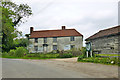
House - Old Roses Farm
Apparently near derelict, certainly extremely shabby, but with a good roof and there was a light on in one of the rooms. A grade II listed building from around 1700.
Image: © Robin Webster
Taken: 21 May 2016
0.17 miles
2
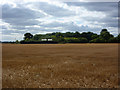
Large field
Seen from the path by the edge of Twinsteadhall Wood.
Image: © Andrew Hill
Taken: 29 Aug 2009
0.18 miles