IMAGES TAKEN NEAR TO
Gainsborough Yard, Sandy Lane, SUDBURY, CO10 7GY
Introduction
This page details the photographs taken nearby to Gainsborough Yard, Sandy Lane, CO10 7GY by members of the Geograph project.
The Geograph project started in 2005 with the aim of publishing, organising and preserving representative images for every square kilometre of Great Britain, Ireland and the Isle of Man.

There are currently over 7.5m images from over14,400 individuals and you can help contribute to the project by visiting https://www.geograph.org.uk
Image Map
Images are licensed for reuse under creativecommons.org/licenses/by-sa/2.0
Notes
- Clicking on the map will re-center to the selected point.
- The higher the marker number, the further away the image location is from the centre of the postcode.
Image Listing (8 Images Found)
Images are licensed for reuse under creativecommons.org/licenses/by-sa/2.0
Image
Details
Distance

4
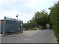
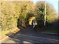
Sandy Lane
The narrow Sandy Lane runs right across this grid square. The grey fence belongs to a household waste facility.
Image: © Oxyman
Taken: 4 May 2007
0.04 miles
5
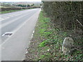
Sudbury To Halstead
Old milestone on the A131 near to Sudbury, Suffolk. For close up view see http://www.geograph.org.uk/photo/1788237
Image: © Keith Evans
Taken: 5 Apr 2010
0.20 miles
6
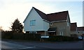
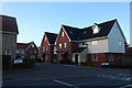
House on the corner of Ballingdon Gardens, Sudbury
Image: © David Howard
Taken: 14 Mar 2019
0.22 miles