IMAGES TAKEN NEAR TO
Fowes Lane, SUDBURY, CO10 7BQ
Introduction
This page details the photographs taken nearby to Fowes Lane, CO10 7BQ by members of the Geograph project.
The Geograph project started in 2005 with the aim of publishing, organising and preserving representative images for every square kilometre of Great Britain, Ireland and the Isle of Man.

There are currently over 7.5m images from over14,400 individuals and you can help contribute to the project by visiting https://www.geograph.org.uk
Image Map (Loading...)


Getting Data...Please wait
Leaflet Map data © OpenStreetMap
Images are licensed for reuse under creativecommons.org/licenses/by-sa/2.0
Notes
- Clicking on the map will re-center to the selected point.
- The higher the marker number, the further away the image location is from the centre of the postcode.
Image Listing (6 Images Found)
Images are licensed for reuse under creativecommons.org/licenses/by-sa/2.0
Image
Details
Distance
1
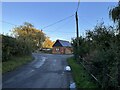
The Old Smithy, Belchamp Otten
View along Otten Road towards The Old Smithy on the corner where Fowe's Lane meets The Street, Belchamp Otten.
Image: © Ajay Tegala
Taken: 24 Oct 2023
0.05 miles
2
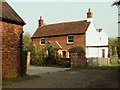
An old cottage at Belchamp Otten
A footpath runs down the right side of the cottage.
Image: © Robert Edwards
Taken: 13 Apr 2007
0.06 miles
3
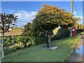
Old village pump and telephone box, Belchamp Otten
The old village water pump and telephone box along The Street in Belchamp Otten.
Image: © Ajay Tegala
Taken: 24 Oct 2023
0.12 miles
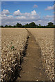
4

Footpath to Belchanp Otten
This path leads eastwards from Otten Road across a field of wheat, towards the hamlet of Belchamp Otten.
Image: © Bob Jones
Taken: 2 Aug 2010
0.19 miles
5
Footpath to Belchamp St Paul
This path leads westwards towards Otten Road and Belchamp St Paul, across a field of wheat, from the hamlet of Belchamp Otten.
Image: © Bob Jones
Taken: 2 Aug 2010
0.19 miles
6
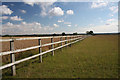
Paddock fencing at Belchamp Otten
This fence extends in an eastward direction from a right-angled bend in the footpath leading to Belchamp Otten.
Image: © Bob Jones
Taken: 2 Aug 2010
0.21 miles