IMAGES TAKEN NEAR TO
Belchamp Walter, SUDBURY, CO10 7BD
Introduction
This page details the photographs taken nearby to CO10 7BD by members of the Geograph project.
The Geograph project started in 2005 with the aim of publishing, organising and preserving representative images for every square kilometre of Great Britain, Ireland and the Isle of Man.

There are currently over 7.5m images from over14,400 individuals and you can help contribute to the project by visiting https://www.geograph.org.uk
Image Map (Loading...)


Getting Data...Please wait
Leaflet Map data © OpenStreetMap
Images are licensed for reuse under creativecommons.org/licenses/by-sa/2.0
Notes
- Clicking on the map will re-center to the selected point.
- The higher the marker number, the further away the image location is from the centre of the postcode.
Image Listing (5 Images Found)
Images are licensed for reuse under creativecommons.org/licenses/by-sa/2.0
Image
Details
Distance
1
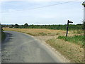
Footpath Sign And Country Side
Footpath sign and country side near to Puttock End, Essex.
Image: © Keith Evans
Taken: 6 Sep 2012
0.04 miles
2
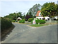
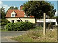
Puttock End
Road junction at Puttock End, Essex.
Image: © Keith Evans
Taken: 6 Sep 2012
0.14 miles
3
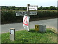
Finger Post
Finger post direction sign at Puttock end, Essex.
Image: © Keith Evans
Taken: 6 Sep 2012
0.15 miles
4
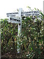
Wooden Finger Post
Wooden finger guide post near to Puttock end, Essex.
Image: © Keith Evans
Taken: 6 Sep 2012
0.19 miles
5
Road junction at Puttock End, Essex
Puttock End lies just south of Belchamp Otten.
Image: © Robert Edwards
Taken: 25 Aug 2006
0.19 miles