IMAGES TAKEN NEAR TO
Wash Lane, SUDBURY, CO10 5JE
Introduction
This page details the photographs taken nearby to Wash Lane, CO10 5JE by members of the Geograph project.
The Geograph project started in 2005 with the aim of publishing, organising and preserving representative images for every square kilometre of Great Britain, Ireland and the Isle of Man.

There are currently over 7.5m images from over14,400 individuals and you can help contribute to the project by visiting https://www.geograph.org.uk
Image Map
Images are licensed for reuse under creativecommons.org/licenses/by-sa/2.0
Notes
- Clicking on the map will re-center to the selected point.
- The higher the marker number, the further away the image location is from the centre of the postcode.
Image Listing (3 Images Found)
Images are licensed for reuse under creativecommons.org/licenses/by-sa/2.0
Image
Details
Distance
1
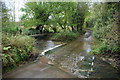
Ford and Footbridge at Stone Street
This pretty ford on Wash Lane is found at Stone Street.
Image: © John Walton
Taken: 8 Nov 2012
0.15 miles
2
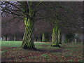
Twisted trees
Twisted laths of wood around a line of trees along the drive to Peyton Hall near Stone Street Suffolk.
Image: © Keith Evans
Taken: 19 Nov 2007
0.21 miles
3
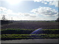
Field at Calais Street
A field at Calais Street with pylons in the distance.
Image: © Hamish Griffin
Taken: 22 Feb 2014
0.23 miles