IMAGES TAKEN NEAR TO
Castlings Heath, SUDBURY, CO10 5ES
Introduction
This page details the photographs taken nearby to Castlings Heath, CO10 5ES by members of the Geograph project.
The Geograph project started in 2005 with the aim of publishing, organising and preserving representative images for every square kilometre of Great Britain, Ireland and the Isle of Man.

There are currently over 7.5m images from over14,400 individuals and you can help contribute to the project by visiting https://www.geograph.org.uk
Image Map (Loading...)


Getting Data...Please wait
Leaflet Map data © OpenStreetMap
Images are licensed for reuse under creativecommons.org/licenses/by-sa/2.0
Notes
- Clicking on the map will re-center to the selected point.
- The higher the marker number, the further away the image location is from the centre of the postcode.
Image Listing (7 Images Found)
Images are licensed for reuse under creativecommons.org/licenses/by-sa/2.0
Image
Details
Distance
1
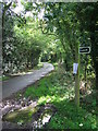
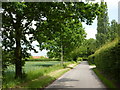
Country Road
Country road and footpath sign near to Groton, Suffolk.
Image: © Keith Evans
Taken: 30 Sep 2010
0.05 miles
2
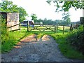
Paddock near Groton
Various sheds dotted around.
Image: © Oliver Dixon
Taken: 8 Jun 2006
0.07 miles
3
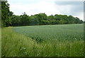
Field corner
The trees are by the lane near Castling's Heath.
Image: © Andrew Hill
Taken: 7 Jun 2010
0.09 miles
4
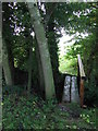
Footbridge
Footbridge near to Groton, Suffolk.
Image: © Keith Evans
Taken: 30 Sep 2010
0.12 miles
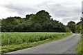
5
Lane at Parliament Heath
A leafy lane by arable fields.
Image: © Andrew Hill
Taken: 7 Jun 2010
0.24 miles
6
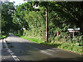
Road Junction
Road junction near to Groton, Suffolk. The road on the left goes to Castling's Heath. Looking towards Broad Street from the Rose Green direction.
Image: © Keith Evans
Taken: 30 Sep 2010
0.25 miles
7
Groton, Manning's Farm: Broad bean crop
Image: © Michael Garlick
Taken: 3 Jul 2020
0.25 miles