IMAGES TAKEN NEAR TO
Bridge Terrace, East Street, SUDBURY, CO10 2TT
Introduction
This page details the photographs taken nearby to Bridge Terrace, East Street, CO10 2TT by members of the Geograph project.
The Geograph project started in 2005 with the aim of publishing, organising and preserving representative images for every square kilometre of Great Britain, Ireland and the Isle of Man.

There are currently over 7.5m images from over14,400 individuals and you can help contribute to the project by visiting https://www.geograph.org.uk
Image Map
Images are licensed for reuse under creativecommons.org/licenses/by-sa/2.0
Notes
- Clicking on the map will re-center to the selected point.
- The higher the marker number, the further away the image location is from the centre of the postcode.
Image Listing (288 Images Found)
Images are licensed for reuse under creativecommons.org/licenses/by-sa/2.0
Image
Details
Distance
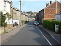
2
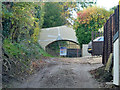
Bridge, Bridge Terrace, Sudbury
The track under the bridge was for road access to a small chalk pit with limekilns, mapped as old in 1885. The way over the bridge is from a high level footpath parallel with the track on the left to the six houses of Bridge Terrace, also at high level on the right, out of sight. It seems likely this was the only access to the front of the houses once, but now there is road access, via this track, at low level and a foot route up to the houses. There is also access from Upper East Street to the rear. In 2014 the chalk pit site, latterly part of the garden of a house above on Queens Close, was being redeveloped for further housing. The access was intended to be through the bridge, and work was done on lowering the track under the bridge. During this the bridge and utilities were damaged, hence the patched up cracks. The planning authority pronounced there was no permission for this work, and work was stopped. The access to the development was changed to be from Queens Close, so the passage under the bridge is blocked. For some reason the footway over the bridge is also now blocked with a short length of high wooden fence set into the hedge along the footpath. The bridge is claimed to be 150 years old. It certainly appears on the 1885 map, with a benchmark on it.
Image: © Robin Webster
Taken: 31 Oct 2015
0.02 miles
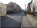
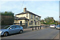
3
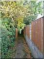
Footpath from Queens Close to East Street, Sudbury
The fencing on the left blocks off use of the old footbridge to Bridge Terrace - see Image for an account of the bridge.
Image: © Robin Webster
Taken: 31 Oct 2015
0.02 miles
7
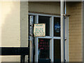
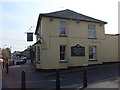
Old bus stop sign, East Street, Sudbury, 2015
Outside the Horse & Groom, this is a standard style used by the nationalized regional bus companies in the 1950s, at least in this part of the country. Probably Eastern Counties, although Eastern National operated in Essex, just over the Stour. The sign is now removed.
Image: © Robin Webster
Taken: 31 Oct 2015
0.04 miles
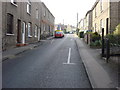
10
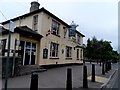
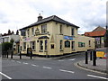
The Horse & Groom pub, Sudbury
On the corner of East Street and Upper East Street.
Image: © Robin Webster
Taken: 31 Oct 2015
0.05 miles