IMAGES TAKEN NEAR TO
St. Leonards Drive, SUDBURY, CO10 2RQ
Introduction
This page details the photographs taken nearby to St. Leonards Drive, CO10 2RQ by members of the Geograph project.
The Geograph project started in 2005 with the aim of publishing, organising and preserving representative images for every square kilometre of Great Britain, Ireland and the Isle of Man.

There are currently over 7.5m images from over14,400 individuals and you can help contribute to the project by visiting https://www.geograph.org.uk
Image Map
Images are licensed for reuse under creativecommons.org/licenses/by-sa/2.0
Notes
- Clicking on the map will re-center to the selected point.
- The higher the marker number, the further away the image location is from the centre of the postcode.
Image Listing (261 Images Found)
Images are licensed for reuse under creativecommons.org/licenses/by-sa/2.0
Image
Details
Distance
1
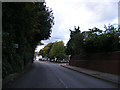
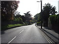
A131 Newton Road, Sudbury
Approaching the junction with Belle Vue Road
Image: © Geographer
Taken: 4 Oct 2013
0.03 miles
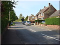
6
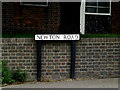
Newton Road sign
On the A134 Newton Road at the junction with the A134 King Street near Sudbury Telephone Exchange
Image: © Geographer
Taken: 22 May 2014
0.11 miles
7
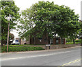
Sudbury Telephone Exchange
Off the A134 Newton Road at the junction with the A134 King Street
Image: © Geographer
Taken: 22 May 2014
0.11 miles