IMAGES TAKEN NEAR TO
Chilton Lodge Road, SUDBURY, CO10 2HD
Introduction
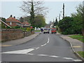
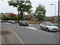
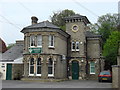
This page details the photographs taken nearby to Chilton Lodge Road, CO10 2HD by members of the Geograph project.
The Geograph project started in 2005 with the aim of publishing, organising and preserving representative images for every square kilometre of Great Britain, Ireland and the Isle of Man.

There are currently over 7.5m images from over14,400 individuals and you can help contribute to the project by visiting https://www.geograph.org.uk
Image Map (Loading...)


Getting Data...Please wait
Leaflet Map data © OpenStreetMap
Images are licensed for reuse under creativecommons.org/licenses/by-sa/2.0
Notes
- Clicking on the map will re-center to the selected point.
- The higher the marker number, the further away the image location is from the centre of the postcode.
Image Listing (47 Images Found)
Images are licensed for reuse under creativecommons.org/licenses/by-sa/2.0
Image
Details
Distance

6
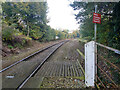
Sudbury branch line
Looking from a level crossing, not far from the station and end of the line, towards the rest of the world via Marks Tey.
Image: © Robin Webster
Taken: 31 Oct 2015
0.11 miles
7
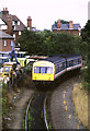
Train approaching Sudbury
A diesel multiple unit approaching Sudbury station in Suffolk. Sudbury is now the terminus at the end of a branch line. The line used to continue beyond Sudbury, with branches to Haverhill and Bury St. Edmunds.
Image: © Malc McDonald
Taken: 29 Jul 1990
0.11 miles