IMAGES TAKEN NEAR TO
First Avenue, SUDBURY, CO10 1YU
Introduction
This page details the photographs taken nearby to First Avenue, CO10 1YU by members of the Geograph project.
The Geograph project started in 2005 with the aim of publishing, organising and preserving representative images for every square kilometre of Great Britain, Ireland and the Isle of Man.

There are currently over 7.5m images from over14,400 individuals and you can help contribute to the project by visiting https://www.geograph.org.uk
Image Map (10 Images)


Getting Data...Please wait
Leaflet Map data © OpenStreetMap
Images are licensed for reuse under creativecommons.org/licenses/by-sa/2.0
Notes
- Clicking on the map will re-center to the selected point.
- The higher the marker number, the further away the image location is from the centre of the postcode.
Image Listing (10 Images Found)
Images are licensed for reuse under creativecommons.org/licenses/by-sa/2.0
Image
Details
Distance


8
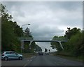
Footbridge over A134 by Drake Road
There are several footbridges over the Sudbury bypass giving safe links for walkers and cyclists over the busy road
Image: © David Smith
Taken: 19 Jun 2014
0.23 miles
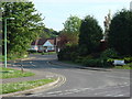
9
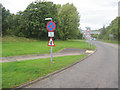
Springlands way from Waldingfield Roundabout
Look North just west of Chilton
Image: © John Firth
Taken: 16 Sep 2010
0.24 miles
