IMAGES TAKEN NEAR TO
York Road, SUDBURY, CO10 1NE
Introduction
This page details the photographs taken nearby to York Road, CO10 1NE by members of the Geograph project.
The Geograph project started in 2005 with the aim of publishing, organising and preserving representative images for every square kilometre of Great Britain, Ireland and the Isle of Man.

There are currently over 7.5m images from over14,400 individuals and you can help contribute to the project by visiting https://www.geograph.org.uk
Image Map (Loading...)


Getting Data...Please wait
Leaflet Map data © OpenStreetMap
Images are licensed for reuse under creativecommons.org/licenses/by-sa/2.0
Notes
- Clicking on the map will re-center to the selected point.
- The higher the marker number, the further away the image location is from the centre of the postcode.
Image Listing (154 Images Found)
Images are licensed for reuse under creativecommons.org/licenses/by-sa/2.0
Image
Details
Distance
2
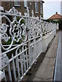
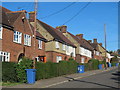
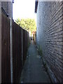
Victorian Iron Railings, Stanley road
Many Iron railings like this were sacrificed for the war effort, making the sight of original Victorian railings like this quite rare.
Image: © Oxyman
Taken: 13 Sep 2007
0.04 miles
10
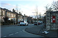
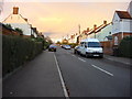
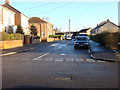
York Road at the junction of Clarence Road
Image: © David Howard
Taken: 14 Mar 2019
0.08 miles