IMAGES TAKEN NEAR TO
Tudor Road, SUDBURY, CO10 1LD
Introduction
This page details the photographs taken nearby to Tudor Road, CO10 1LD by members of the Geograph project.
The Geograph project started in 2005 with the aim of publishing, organising and preserving representative images for every square kilometre of Great Britain, Ireland and the Isle of Man.

There are currently over 7.5m images from over14,400 individuals and you can help contribute to the project by visiting https://www.geograph.org.uk
Image Map
Images are licensed for reuse under creativecommons.org/licenses/by-sa/2.0
Notes
- Clicking on the map will re-center to the selected point.
- The higher the marker number, the further away the image location is from the centre of the postcode.
Image Listing (48 Images Found)
Images are licensed for reuse under creativecommons.org/licenses/by-sa/2.0
Image
Details
Distance
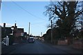
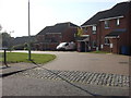
1
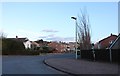
Priory Road at the junction of Tudor Road
Image: © David Howard
Taken: 14 Mar 2019
0.06 miles
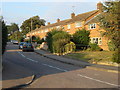
2
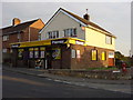
Strawberry Convenience Store
Taken from Tudor Road
Image: © Oxyman
Taken: 13 Sep 2007
0.11 miles
4
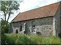
St Bartholomew's, Sudbury
A Chapel of Ease, now derelict, about to be swamped by a new housing development known as 'The Priory'.
Image: © Bob Jones
Taken: 15 Jun 2006
0.14 miles
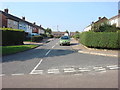
8
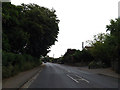
A131 Melford Road, Sudbury
At the junction with Abbey Road
Image: © Geographer
Taken: 22 May 2014
0.17 miles
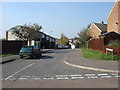
10
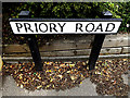
Priory Road sign
On Priory Road at the junction with the A131 Melford Road
Image: © Geographer
Taken: 22 May 2014
0.18 miles