IMAGES TAKEN NEAR TO
Melford Road, SUDBURY, CO10 1HX
Introduction
This page details the photographs taken nearby to Melford Road, CO10 1HX by members of the Geograph project.
The Geograph project started in 2005 with the aim of publishing, organising and preserving representative images for every square kilometre of Great Britain, Ireland and the Isle of Man.

There are currently over 7.5m images from over14,400 individuals and you can help contribute to the project by visiting https://www.geograph.org.uk
Image Map
Images are licensed for reuse under creativecommons.org/licenses/by-sa/2.0
Notes
- Clicking on the map will re-center to the selected point.
- The higher the marker number, the further away the image location is from the centre of the postcode.
Image Listing (401 Images Found)
Images are licensed for reuse under creativecommons.org/licenses/by-sa/2.0
Image
Details
Distance
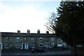
1
Melford Road, Sudbury
The left fork begins a fairly winding one way system
Image: © David Howard
Taken: 14 Mar 2019
0.00 miles
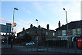
4
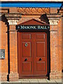
Door of the Masonic Hall, North Street, CO10
See Image
Image: © Mike Quinn
Taken: 30 Oct 2013
0.02 miles
7
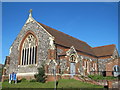
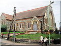
St. John's Methodist Church, York Road / Girling Street, CO10
Image: © Mike Quinn
Taken: 30 Oct 2013
0.03 miles
8
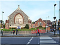
St. Johns Methodist Church, Sudbury
Built around 1900, if maps are to be believed.
Image: © Robin Webster
Taken: 31 Oct 2015
0.03 miles
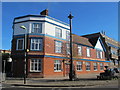
9
The Masonic Hall, Sudbury
This building is at the north end of North Street.
Image: © Oxyman
Taken: 3 Aug 2007
0.03 miles