IMAGES TAKEN NEAR TO
Church Walk, SUDBURY, CO10 1HH
Introduction
This page details the photographs taken nearby to Church Walk, CO10 1HH by members of the Geograph project.
The Geograph project started in 2005 with the aim of publishing, organising and preserving representative images for every square kilometre of Great Britain, Ireland and the Isle of Man.

There are currently over 7.5m images from over14,400 individuals and you can help contribute to the project by visiting https://www.geograph.org.uk
Image Map
Images are licensed for reuse under creativecommons.org/licenses/by-sa/2.0
Notes
- Clicking on the map will re-center to the selected point.
- The higher the marker number, the further away the image location is from the centre of the postcode.
Image Listing (661 Images Found)
Images are licensed for reuse under creativecommons.org/licenses/by-sa/2.0
Image
Details
Distance
1
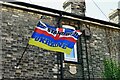
Sudbury, Action Place: Variation on the usual blue and yellow flag
Image: © Michael Garlick
Taken: 15 Sep 2023
0.01 miles
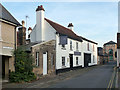
4
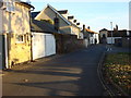
Church Walk, Sudbury
Looking from Acton Square.
Image: © Robin Webster
Taken: 31 Oct 2015
0.02 miles
5
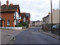
Croft Road, Sudbury
Looking towards Gaol Lane at the junction with Inkerman
Image: © Geographer
Taken: 4 Oct 2013
0.02 miles
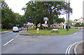
6
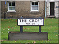
The Croft sign
On The Croft at the junction with the A131 Gregory Street
Image: © Geographer
Taken: 4 Oct 2013
0.03 miles
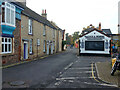
7
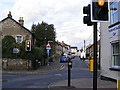
New Street, Sudbury
At the junction with Croft Road
Image: © Geographer
Taken: 4 Oct 2013
0.03 miles
8
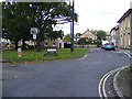
The Croft, Sudbury
At the junction with the A131 Gregory Street
Image: © Geographer
Taken: 4 Oct 2013
0.03 miles
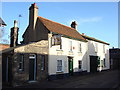
9
Waggon and Horses, Sudbury
On Church Walk.
Image: © Robin Webster
Taken: 31 Oct 2015
0.03 miles
10
A131 Gregory Street, Sudbury
At the junction with The Croft
Image: © Geographer
Taken: 4 Oct 2013
0.03 miles