IMAGES TAKEN NEAR TO
Gregory Street, SUDBURY, CO10 1HE
Introduction
This page details the photographs taken nearby to Gregory Street, CO10 1HE by members of the Geograph project.
The Geograph project started in 2005 with the aim of publishing, organising and preserving representative images for every square kilometre of Great Britain, Ireland and the Isle of Man.

There are currently over 7.5m images from over14,400 individuals and you can help contribute to the project by visiting https://www.geograph.org.uk
Image Map (Loading...)


Getting Data...Please wait
Leaflet Map data © OpenStreetMap
Images are licensed for reuse under creativecommons.org/licenses/by-sa/2.0
Notes
- Clicking on the map will re-center to the selected point.
- The higher the marker number, the further away the image location is from the centre of the postcode.
Image Listing (695 Images Found)
Images are licensed for reuse under creativecommons.org/licenses/by-sa/2.0
Image
Details
Distance
2
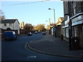
Vanners mill shop
Vanners mill shop Sudbury Suffolk. For a close-up of their old sign see http://www.geograph.org.uk/photo/691268 For info on the company see http://www.vanners.com/
Image: © Keith Evans
Taken: 13 Feb 2008
0.03 miles
3
Cross of Sacrifice, Sudbury: September 2019
Also see https://en.wikipedia.org/wiki/Cross_of_Sacrifice
Image: © Basher Eyre
Taken: 16 Sep 2019
0.03 miles
4
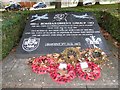
486th Bombardment Group Memorial: September 2019
Also see http://486th.org/
Image: © Basher Eyre
Taken: 16 Sep 2019
0.03 miles
5
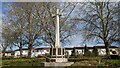
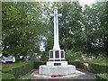
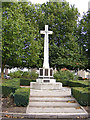
Sudbury War Memorial
https://historicengland.org.uk/listing/the-list/list-entry/1389148?section=official-list-entry
Image: © Sandy Gerrard
Taken: 10 Apr 2023
0.03 miles
7
War Memorial
Off the A131 Gregory Street near St.Gregory's Church
Image: © Geographer
Taken: 4 Oct 2013
0.04 miles
8
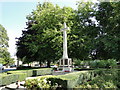
Sudbury War Memorial
Built in the style of a Cross of Sacrifice and standing virtually opposite the south door of St. Gregory's church it bears the 238 names of Sudbury's fallen of the Great War, 1914-1918.
In addition to the service personnel are five names of civilians killed in a bombing raid by Zeppelin L.14 on 31st March 1916. https://www.geograph.org.uk/photo/6574841
The smaller plaques on the third step of the base bear 58 names of the men who were killed in the Second World War.
A small plaque bearing the name of J R Howard who was killed in Northern Ireland in 1988, is also evident on the rear facet of the memorial.
Image: © Adrian S Pye
Taken: 31 Aug 2017
0.04 miles
9
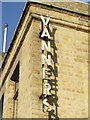
Vanners sign
An old name sign on Vanners mill shop Sudbury, Suffolk for full photo see http://www.geograph.org.uk/photo/691269 and info on the company see http://www.vanners.com/
Image: © Keith Evans
Taken: 13 Feb 2008
0.04 miles
10
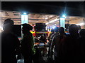
Dunwich Dynamo 2015, fire station, Sudbury
The Dunwich Dynamo is a semi-organised bike ride from Hackney, London to the lost town of Dunwich in Suffolk. The ride takes place overnight on a Saturday/Sunday closest to midsummer when the moon is full. The ride typically attracts 1500+ riders.
Here riders are queuing for burgers and hot dogs at 2.30 am at the barbeque at Sudbury firestation.
Image: © Bikeboy
Taken: 5 Jul 2015
0.04 miles