IMAGES TAKEN NEAR TO
Reliant Close, SUDBURY, CO10 0WQ
Introduction
This page details the photographs taken nearby to Reliant Close, CO10 0WQ by members of the Geograph project.
The Geograph project started in 2005 with the aim of publishing, organising and preserving representative images for every square kilometre of Great Britain, Ireland and the Isle of Man.

There are currently over 7.5m images from over14,400 individuals and you can help contribute to the project by visiting https://www.geograph.org.uk
Image Map
Images are licensed for reuse under creativecommons.org/licenses/by-sa/2.0
Notes
- Clicking on the map will re-center to the selected point.
- The higher the marker number, the further away the image location is from the centre of the postcode.
Image Listing (4 Images Found)
Images are licensed for reuse under creativecommons.org/licenses/by-sa/2.0
Image
Details
Distance
1
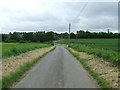
Road Junction Ahead
Road junction ahead near to Acton, Suffolk.
Image: © Keith Evans
Taken: 7 Jun 2012
0.08 miles
3
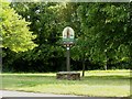
Village sign at Acton, Suffolk
This sign shows the knight that can be seen, as a brass, in the nearby parish church.
Image: © Robert Edwards
Taken: 31 May 2006
0.22 miles
4
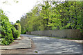
Wattle fence, Vicarage Lane, Acton
Fencing the grounds of The Old Vicarage, it looks to have been built up in situ. There is no obvious sign of panels, it has a continuous top rail and it has some tightly curved parts at the entrances.
Image: © Robin Webster
Taken: 17 Apr 2017
0.23 miles