IMAGES TAKEN NEAR TO
Tentree Road, SUDBURY, CO10 0SD
Introduction
This page details the photographs taken nearby to Tentree Road, CO10 0SD by members of the Geograph project.
The Geograph project started in 2005 with the aim of publishing, organising and preserving representative images for every square kilometre of Great Britain, Ireland and the Isle of Man.

There are currently over 7.5m images from over14,400 individuals and you can help contribute to the project by visiting https://www.geograph.org.uk
Image Map
Images are licensed for reuse under creativecommons.org/licenses/by-sa/2.0
Notes
- Clicking on the map will re-center to the selected point.
- The higher the marker number, the further away the image location is from the centre of the postcode.
Image Listing (16 Images Found)
Images are licensed for reuse under creativecommons.org/licenses/by-sa/2.0
Image
Details
Distance
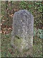
1
Old Milestone
Old milestone near to Lavenham, Suffolk. For close up view see http://www.geograph.org.uk/photo/1713280 for more info on the post see http://milestones.megalithia.com/sites/tl905438.htm and do have a look at their home page.
Image: © Keith Evans
Taken: 16 Feb 2010
0.09 miles
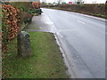
2
Old Milestone
Old milestone near to Great Waldingfield, Suffolk. For overall view see http://www.geograph.org.uk/photo/1713278 for more info on the post see http://milestones.megalithia.com/sites/tl905438.htm and do have a look at their home page.
Image: © Keith Evans
Taken: 16 Feb 2010
0.10 miles
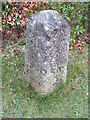
3
Old Milestone by the B1071, The Heath, Great Waldingfield
Carved stone post by the B1071, in parish of Great Waldingfield (Babergh District), Meadowcroft, The Heath, grass in front of domestic hedge, on East side of road. Sudbury old pillar erected by the Sudbury to Bury St Edmunds Turnpike Trust in the 19th century.
Inscription reads:-
: LIX / TO / LONDON / III / TO / SUDBURY : : LIX / MILES / FROM / LONDON / (IV) / TO / LAVENHAM / XIV / TO / BURY :
Suffolk HER.
HER Number (Pref. Ref.): WFG 059 https://www.heritagegateway.org.uk/Gateway/Results_Single.aspx?uid=MSF18271&resourceID=1017
Milestone Society National ID: SU_SBLV03.
Image: © Milestone Society
Taken: 16 Feb 2019
0.11 miles
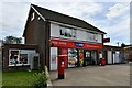
4
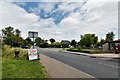
Great Waldingfield: The Heath (B1115)
Image: © Michael Garlick
Taken: 3 Jul 2020
0.12 miles
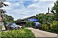
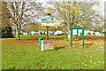
6
Great Waldingfield: Village sign and notice board
Image: © Michael Garlick
Taken: 3 Jul 2020
0.15 miles
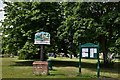
7
Village Sign
Great Waldingfield village sign at Great Waldingfield, Suffolk.
Image: © Keith Evans
Taken: 15 Dec 2011
0.15 miles
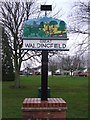
8
Great Waldingfield village sign on Green Acre
The carved wooden sign shows the church and a number of trees, amongst which are a set of scales which probably indirectly, represent the wool and weaving trade. An ancient plough in the foreground symbolises the agricultural heritage of the parish. A field of cereal crop is painted yellow and there are sheep on the hill above. The sign appears to be the work of a child from the local school.
See a close up and more about the sign here https://www.geograph.org.uk/photo/6655696
Image: © Adrian S Pye
Taken: 26 Oct 2020
0.15 miles
9
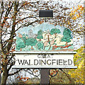
Great Waldingfield village sign
The carved wooden sign shows the church and a number of trees, amongst which are a set of scales which probably indirectly, represent the wool and weaving trade. An ancient plough in the foreground symbolises the agricultural heritage of the parish. A field of cereal crop is painted yellow and there are sheep on the hill above. The sign appears to be the work of a child from the local school.
https://www.geograph.org.uk/photo/6655839
Image: © Adrian S Pye
Taken: 26 Oct 2020
0.15 miles