IMAGES TAKEN NEAR TO
Upper Tye, SUDBURY, CO10 0QA
Introduction
This page details the photographs taken nearby to Upper Tye, CO10 0QA by members of the Geograph project.
The Geograph project started in 2005 with the aim of publishing, organising and preserving representative images for every square kilometre of Great Britain, Ireland and the Isle of Man.

There are currently over 7.5m images from over14,400 individuals and you can help contribute to the project by visiting https://www.geograph.org.uk
Image Map
Images are licensed for reuse under creativecommons.org/licenses/by-sa/2.0
Notes
- Clicking on the map will re-center to the selected point.
- The higher the marker number, the further away the image location is from the centre of the postcode.
Image Listing (12 Images Found)
Images are licensed for reuse under creativecommons.org/licenses/by-sa/2.0
Image
Details
Distance


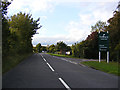
3
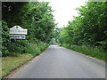
Entering Cornard Tye
Entering Cornard Tye, Suffolk from the north.
Image: © Keith Evans
Taken: 20 Jun 2013
0.11 miles

5
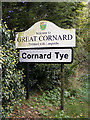
Cornard Tye Village name sign
On Joes Road
Image: © Geographer
Taken: 4 Oct 2013
0.12 miles
6
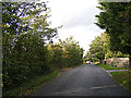
Joes Road, Cornard Tye
Looking towards the A134 Sudbury Road
Image: © Geographer
Taken: 4 Oct 2013
0.12 miles
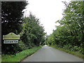
8

Joes Road, Great Cornard
At the junction with the A134 Sudbury Road
Image: © Geographer
Taken: 4 Oct 2013
0.21 miles
9

A134 Sudbury Road, Great Cornard
At the junction with Joes Road
Image: © Geographer
Taken: 4 Oct 2013
0.21 miles
10
A134 Newton Road, Chilton
Looking towards Sudbury at the entrance to Sudbury Garden Centre
Image: © Geographer
Taken: 4 Oct 2013
0.24 miles