IMAGES TAKEN NEAR TO
Chilton Grove, Waldingfield Road, SUDBURY, CO10 0PR
Introduction
This page details the photographs taken nearby to Chilton Grove, Waldingfield Road, CO10 0PR by members of the Geograph project.
The Geograph project started in 2005 with the aim of publishing, organising and preserving representative images for every square kilometre of Great Britain, Ireland and the Isle of Man.

There are currently over 7.5m images from over14,400 individuals and you can help contribute to the project by visiting https://www.geograph.org.uk
Image Map
Images are licensed for reuse under creativecommons.org/licenses/by-sa/2.0
Notes
- Clicking on the map will re-center to the selected point.
- The higher the marker number, the further away the image location is from the centre of the postcode.
Image Listing (6 Images Found)
Images are licensed for reuse under creativecommons.org/licenses/by-sa/2.0
Image
Details
Distance
1
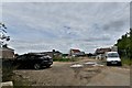
Great Waldingfield: Small housing development
Image: © Michael Garlick
Taken: 3 Jul 2020
0.01 miles
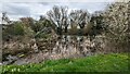
4
Waldingfield Airfield
The main runway of the WW2 airfield.
Image: © Dave King
Taken: 19 Dec 2006
0.17 miles
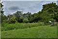
5
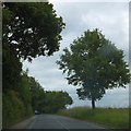
Woodland by Waldingfield Road (B1115)
The woodland on the left screens the former Waldingfield airfield, location for several businesses
Image: © David Smith
Taken: 19 Jun 2014
0.20 miles
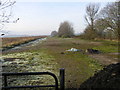
6
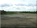
Main Runway
Looking along on what would have been the main runway of the former WWII airfield R.A.F. Sudbury near to Great Waldingfield, Suffolk. For more info on the airfield see http://en.wikipedia.org/wiki/RAF_Sudbury
Image: © Keith Evans
Taken: 7 Jun 2012
0.21 miles