IMAGES TAKEN NEAR TO
Upper Road, SUDBURY, CO10 0PA
Introduction
This page details the photographs taken nearby to Upper Road, CO10 0PA by members of the Geograph project.
The Geograph project started in 2005 with the aim of publishing, organising and preserving representative images for every square kilometre of Great Britain, Ireland and the Isle of Man.

There are currently over 7.5m images from over14,400 individuals and you can help contribute to the project by visiting https://www.geograph.org.uk
Image Map
Images are licensed for reuse under creativecommons.org/licenses/by-sa/2.0
Notes
- Clicking on the map will re-center to the selected point.
- The higher the marker number, the further away the image location is from the centre of the postcode.
Image Listing (5 Images Found)
Images are licensed for reuse under creativecommons.org/licenses/by-sa/2.0
Image
Details
Distance
1
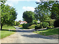
Upper Road, Workhouse Green
Well-to-do rather than workhouse now.
Image: © Robin Webster
Taken: 17 Jun 2017
0.06 miles
2
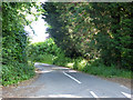
Lane north from Pond Farm
Either Chapel Lane or a continuation of Upper Road.
Image: © Robin Webster
Taken: 17 Jun 2017
0.13 miles
3
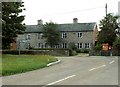
Houses at Workhouse Green, Suffolk
These cottages were built for farm workers in 1870.
The 'Workhouse' was to the right of this picture and was formed from a group of timber framed cottages now combined as a large dwelling and the cottage on the opposite side of Spout Lane appears to have been used as a dormitory. The terrace shown were originally 2up, 2down workers cottages (circa 1865). They had a communal bakehouse to the rear with long plots for cultivation (now occupied by two houses). (Additional information provided by John Quick.)
Image: © Robert Edwards
Taken: 28 Aug 2006
0.17 miles
4
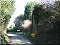
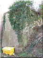
Find The Pillbox
WWII pillbox high up the concrete wall on the right at Workhouse Green, Suffolk. For other view see http://www.geograph.org.uk/photo/2844209
Image: © Keith Evans
Taken: 8 Mar 2012
0.19 miles
5
Advantage Point
WWII pillbox high up the concrete wall at Workhouse Green, Suffolk. For other view see http://www.geograph.org.uk/photo/2844203
Image: © Keith Evans
Taken: 8 Mar 2012
0.19 miles