IMAGES TAKEN NEAR TO
Blackhouse Lane, SUDBURY, CO10 0NL
Introduction
This page details the photographs taken nearby to Blackhouse Lane, CO10 0NL by members of the Geograph project.
The Geograph project started in 2005 with the aim of publishing, organising and preserving representative images for every square kilometre of Great Britain, Ireland and the Isle of Man.

There are currently over 7.5m images from over14,400 individuals and you can help contribute to the project by visiting https://www.geograph.org.uk
Image Map
Images are licensed for reuse under creativecommons.org/licenses/by-sa/2.0
Notes
- Clicking on the map will re-center to the selected point.
- The higher the marker number, the further away the image location is from the centre of the postcode.
Image Listing (8 Images Found)
Images are licensed for reuse under creativecommons.org/licenses/by-sa/2.0
Image
Details
Distance
1
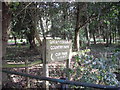
Sign at entrance to Great Cornard Country Park
The sign is visible from Blackhouse Road
Image: © PAUL FARMER
Taken: 29 Aug 2009
0.06 miles
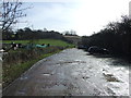
2
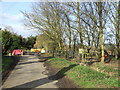
Road Closed
Road closed outside the Country Park at Great Cornard, Suffolk.
Image: © Keith Evans
Taken: 8 Mar 2012
0.06 miles
3
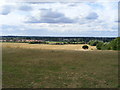
View from Kedington Hill toward Great Cornard
Blackhouse farm and Cornard United football pitch are visible at the centre of the picture
Image: © PAUL FARMER
Taken: 29 Aug 2009
0.10 miles
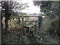
4
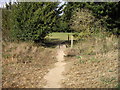
Footbridge leading to picnic area
Within Great Cornard Country Park
Image: © PAUL FARMER
Taken: 29 Aug 2009
0.12 miles
5
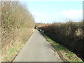
Blackhouse Lane
Blackhouse Lane looking east near to Little Cornard, Suffolk.
Image: © Keith Evans
Taken: 8 Mar 2012
0.13 miles
7
Allotments And Car Park
Allotments and car park near to Great Cornard, Suffolk.
Image: © Keith Evans
Taken: 8 Mar 2012
0.21 miles
8
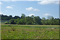
Cornard Mere
The trees across the field surround the mere and its wetland, a nature reserve.
Image: © Robin Webster
Taken: 17 Jun 2017
0.24 miles