IMAGES TAKEN NEAR TO
Pot Kiln Road, SUDBURY, CO10 0DH
Introduction
This page details the photographs taken nearby to Pot Kiln Road, CO10 0DH by members of the Geograph project.
The Geograph project started in 2005 with the aim of publishing, organising and preserving representative images for every square kilometre of Great Britain, Ireland and the Isle of Man.

There are currently over 7.5m images from over14,400 individuals and you can help contribute to the project by visiting https://www.geograph.org.uk
Image Map
Images are licensed for reuse under creativecommons.org/licenses/by-sa/2.0
Notes
- Clicking on the map will re-center to the selected point.
- The higher the marker number, the further away the image location is from the centre of the postcode.
Image Listing (4 Images Found)
Images are licensed for reuse under creativecommons.org/licenses/by-sa/2.0
Image
Details
Distance
1
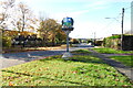
Great Cornard village sign and Pot Kiln Road
Image: © Adrian S Pye
Taken: 26 Oct 2020
0.04 miles
2
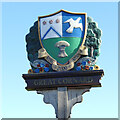
Great Cornard village sign
The shield has a Heraldic device, a dove and wheat sheaf. The colourfully decorated background has trees, flowers and ears of wheat. This is a replacement erected in 2018, because the original was rotting. https://www.geograph.org.uk/photo/6655834
Image: © Adrian S Pye
Taken: 26 Oct 2020
0.09 miles
4
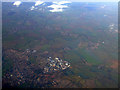
Sudbury from the air
Former RAF Sudbury http://en.wikipedia.org/wiki/RAF_Sudbury is visible near the centre of the photo.
Image: © Thomas Nugent
Taken: 18 Nov 2011
0.25 miles