IMAGES TAKEN NEAR TO
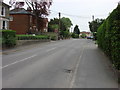
Pot Kiln Road, SUDBURY, CO10 0DA
Introduction
This page details the photographs taken nearby to Pot Kiln Road, CO10 0DA by members of the Geograph project.
The Geograph project started in 2005 with the aim of publishing, organising and preserving representative images for every square kilometre of Great Britain, Ireland and the Isle of Man.

There are currently over 7.5m images from over14,400 individuals and you can help contribute to the project by visiting https://www.geograph.org.uk
Image Map
Images are licensed for reuse under creativecommons.org/licenses/by-sa/2.0
Notes
- Clicking on the map will re-center to the selected point.
- The higher the marker number, the further away the image location is from the centre of the postcode.
Image Listing (22 Images Found)
Images are licensed for reuse under creativecommons.org/licenses/by-sa/2.0
Image
Details
Distance
1
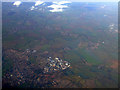
Sudbury from the air
Former RAF Sudbury http://en.wikipedia.org/wiki/RAF_Sudbury is visible near the centre of the photo.
Image: © Thomas Nugent
Taken: 18 Nov 2011
0.01 miles
2
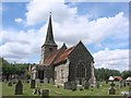
Great Cornard St Andrew?s church
A beautifully proportioned shingle-clad broached spire surmounts the 14th c. tower. On the north side, a brick stair turret has been added to allow easy access to the clock mechanism. The structure is basically 14th century but was heavily restored during the Victorian spending spree. Further 20th c. ‘restoration’ has obliterated some wall paintings of the Elizabethan period that were on the wall of the north aisle. Someone has hoicked several lovely cast iron monuments from the graves and leaned them against the wall of the churchyard, making them a tempting target for metal thieves. I hope they are haunted by those who originally paid for them.
Image: © Adrian S Pye
Taken: 6 Aug 2007
0.09 miles
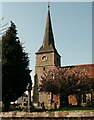
3

The repaired War Memorial at Great Cornard
The missing panel in the memorial has been replaced. The Memorial bears all 33 names of men lost in The Great War and of ten lost in the Second World War.
Image: © Adrian S Pye
Taken: 3 Feb 2017
0.13 miles
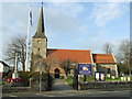
4
Church of St Andrew
https://historicengland.org.uk/listing/the-list/list-entry/1180669?section=official-list-entry
Image: © Sandy Gerrard
Taken: 26 Oct 2024
0.13 miles
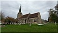
5
St Andrew Great Cornard
The church of St Andrew Great Cornard,Suffolk for more info see http://www.suffolkchurches.co.uk/greatcornard.html
Image: © Keith Evans
Taken: 8 Mar 2012
0.14 miles
6
St. Andrew's church, Great Cornard, Suffolk
This church is mainly 14th century, with a south aisle built in 1887. It stands alongside the B1508 road just south-east of Sudbury.
Image: © Robert Edwards
Taken: 10 May 2006
0.14 miles
7
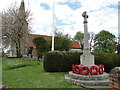
Great Cornard War Memorial
There are 33 names relating to WW1 and ten relating to WW2.
The details can be seen here: http://media.geograph.org.uk/files/fe9fc289c3ff0af142b6d3bead98a923/GREAT_CORNARD_War_Memorial.pdf
Image: © Adrian S Pye
Taken: 27 Apr 2015
0.15 miles