IMAGES TAKEN NEAR TO
Bull Lane, SUDBURY, CO10 0BG
Introduction
This page details the photographs taken nearby to Bull Lane, CO10 0BG by members of the Geograph project.
The Geograph project started in 2005 with the aim of publishing, organising and preserving representative images for every square kilometre of Great Britain, Ireland and the Isle of Man.

There are currently over 7.5m images from over14,400 individuals and you can help contribute to the project by visiting https://www.geograph.org.uk
Image Map
Images are licensed for reuse under creativecommons.org/licenses/by-sa/2.0
Notes
- Clicking on the map will re-center to the selected point.
- The higher the marker number, the further away the image location is from the centre of the postcode.
Image Listing (9 Images Found)
Images are licensed for reuse under creativecommons.org/licenses/by-sa/2.0
Image
Details
Distance
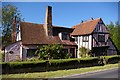
1
Bull Lane Farm
Bull Lane farm near to Long Melford, Suffolk.
Image: © Keith Evans
Taken: 20 Jun 2013
0.02 miles
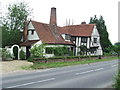
2
The Old Cottage
Next door to the Melford Green Alpacas.
Image: © Fractal Angel
Taken: 4 Aug 2007
0.02 miles
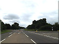
3
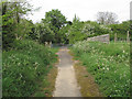
Looking north up King's Lane, Long Melford
King's lane is marked on the map as a bridleway.
Image: © Roger Jones
Taken: 5 May 2014
0.02 miles
4
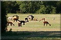
Alpacas near Long Melford
See http://www.melfordgreenalpacas.co.uk/ if you want to buy an alpaca!
Image: © Fractal Angel
Taken: 4 Aug 2007
0.07 miles
5
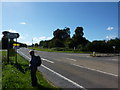
Are you sure this is the right way?
On the edge of the A134, about to return to footpaths and quiet lanes. Near Long Melford.
Image: © Peter Barr
Taken: 15 Sep 2010
0.11 miles
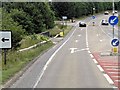
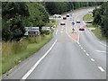
7
A134 Bury Road, Long Melford
At the junction with Bull Lane
Image: © Geographer
Taken: 14 Jun 2014
0.14 miles
8
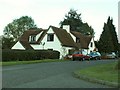
House on the road to Acton from Long Melford
Image: © Robert Edwards
Taken: 1 Nov 2006
0.18 miles