IMAGES TAKEN NEAR TO
Back Road, MALDON, CM9 8TW
Introduction
This page details the photographs taken nearby to Back Road, CM9 8TW by members of the Geograph project.
The Geograph project started in 2005 with the aim of publishing, organising and preserving representative images for every square kilometre of Great Britain, Ireland and the Isle of Man.

There are currently over 7.5m images from over14,400 individuals and you can help contribute to the project by visiting https://www.geograph.org.uk
Image Map (Loading...)


Getting Data...Please wait
Leaflet Map data © OpenStreetMap
Images are licensed for reuse under creativecommons.org/licenses/by-sa/2.0
Notes
- Clicking on the map will re-center to the selected point.
- The higher the marker number, the further away the image location is from the centre of the postcode.
Image Listing (8 Images Found)
Images are licensed for reuse under creativecommons.org/licenses/by-sa/2.0
Image
Details
Distance
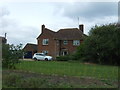
1
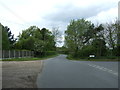
Road junction on Back Road near Bourchier's Farm
Looking west.
Image: © JThomas
Taken: 27 Apr 2017
0.08 miles
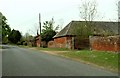
3
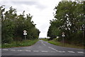
The southern end of Colchester Road
Taken from outside the gates of Guisnes Court.
Image: © Trevor Harris
Taken: 31 Aug 2020
0.11 miles
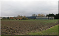
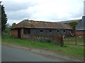
6
Part of Bourchier's Farm on Chapel Road
This view shows Chapel Road in the direction of Tolleshunt D'Arcy.
Image: © Robert Edwards
Taken: 25 Apr 2007
0.14 miles
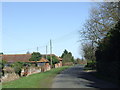
8
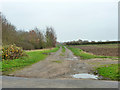
Course of Kelvedon and Tollesbury Light Railway
Looking towards Tollesbury. Traffic on this section finished in 1951.
Image: © Robin Webster
Taken: 6 Dec 2015
0.20 miles