IMAGES TAKEN NEAR TO
Station Road, MALDON, CM9 8TJ
Introduction
This page details the photographs taken nearby to Station Road, CM9 8TJ by members of the Geograph project.
The Geograph project started in 2005 with the aim of publishing, organising and preserving representative images for every square kilometre of Great Britain, Ireland and the Isle of Man.

There are currently over 7.5m images from over14,400 individuals and you can help contribute to the project by visiting https://www.geograph.org.uk
Image Map (5 Images)


Getting Data...Please wait
Leaflet Map data © OpenStreetMap
Images are licensed for reuse under creativecommons.org/licenses/by-sa/2.0
Notes
- Clicking on the map will re-center to the selected point.
- The higher the marker number, the further away the image location is from the centre of the postcode.
Image Listing (5 Images Found)
Images are licensed for reuse under creativecommons.org/licenses/by-sa/2.0
Image
Details
Distance
1
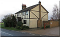
Old Station House, Tolleshunt D'Arcy
Near the route of the erstwhile Kelvedon and Tollesbury Light Railway.
Image: © Roger Jones
Taken: 1 Dec 2019
0.00 miles
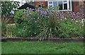
2

Field by Station Road, Tolleshunt D'Arcy
Image: © David Howard
Taken: 23 Feb 2019
0.06 miles
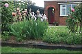
3
Front garden on Station Road, Tolleshunt D'Arcy
Image: © David Howard
Taken: 6 Jun 2021
0.12 miles
4
Front garden on Station Road, Tolleshunt D'Arcy
Image: © David Howard
Taken: 6 Jun 2021
0.13 miles
5
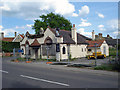
The Former Thatchers Arms Public House Tolleshunt D'Arcy
The pub closed in early 2008 and has since been demolished for housing to be built on the site
Image: © Phil Gaskin
Taken: 21 May 2009
0.23 miles