IMAGES TAKEN NEAR TO
Mell Road, MALDON, CM9 8SW
Introduction
This page details the photographs taken nearby to Mell Road, CM9 8SW by members of the Geograph project.
The Geograph project started in 2005 with the aim of publishing, organising and preserving representative images for every square kilometre of Great Britain, Ireland and the Isle of Man.

There are currently over 7.5m images from over14,400 individuals and you can help contribute to the project by visiting https://www.geograph.org.uk
Image Map
Images are licensed for reuse under creativecommons.org/licenses/by-sa/2.0
Notes
- Clicking on the map will re-center to the selected point.
- The higher the marker number, the further away the image location is from the centre of the postcode.
Image Listing (4 Images Found)
Images are licensed for reuse under creativecommons.org/licenses/by-sa/2.0
Image
Details
Distance
1
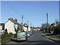
Mell Road, Tollesbury
Mell Road in Tollesbury, Essex.
Image: © Malc McDonald
Taken: 20 Apr 2013
0.11 miles
2
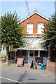
Butcher's shop, Tollesbury
G. Leavett butcher - and fishmonger - in East Street, Tollesbury.
Image: © Trevor Harris
Taken: 27 Sep 2013
0.13 miles
3
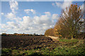
Footpath to Bohuns Hall
This path follows the line of the hedgerow westwards from the end of Mell Road, Tollesbury.
Image: © Bob Jones
Taken: 11 Nov 2008
0.23 miles
4
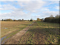
Footpath between Church Street and Mell Road, Tollesbury
Public footpath running through farm land between Church Street and Mell Road, Tollesbury
Image: © Roger Jones
Taken: 9 Feb 2014
0.25 miles