IMAGES TAKEN NEAR TO
Church Road, MALDON, CM9 8NS
Introduction
This page details the photographs taken nearby to Church Road, CM9 8NS by members of the Geograph project.
The Geograph project started in 2005 with the aim of publishing, organising and preserving representative images for every square kilometre of Great Britain, Ireland and the Isle of Man.

There are currently over 7.5m images from over14,400 individuals and you can help contribute to the project by visiting https://www.geograph.org.uk
Image Map (Loading...)


Getting Data...Please wait
Leaflet Map data © OpenStreetMap
Images are licensed for reuse under creativecommons.org/licenses/by-sa/2.0
Notes
- Clicking on the map will re-center to the selected point.
- The higher the marker number, the further away the image location is from the centre of the postcode.
Image Listing (6 Images Found)
Images are licensed for reuse under creativecommons.org/licenses/by-sa/2.0
Image
Details
Distance
1
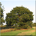
Oak tree on field boundary, off Church Road, Great Totham
Image: © Roger Jones
Taken: 21 Sep 2014
0.15 miles
2
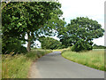
Lane from Great Totham to Little Totham
Church Road, the church being that of Great Totham.
Image: © Robin Webster
Taken: 21 Jun 2015
0.17 miles
3
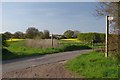
Church Road
This is the junction of the footpath from Sheepcotes farm to Great Totham.
Image: © Glyn Baker
Taken: 2 May 2013
0.20 miles
4
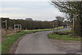
Footpath signs and bridge on Church Road, Great Totham
Footpath running along a steam passes over this rural road.
Image: © Roger Jones
Taken: 25 Jan 2015
0.21 miles
5

Spickets Brook
The footpath to Great Totham runs to the left of the Brook
Image: © Glyn Baker
Taken: 2 May 2013
0.21 miles
6

Sheepcotes Farm Drive
This drive is the footpath to Shepcotes farm and on to Little Totham hall
Image: © Glyn Baker
Taken: 2 May 2013
0.23 miles