IMAGES TAKEN NEAR TO
Barnhall Road, MALDON, CM9 8HD
Introduction
This page details the photographs taken nearby to Barnhall Road, CM9 8HD by members of the Geograph project.
The Geograph project started in 2005 with the aim of publishing, organising and preserving representative images for every square kilometre of Great Britain, Ireland and the Isle of Man.

There are currently over 7.5m images from over14,400 individuals and you can help contribute to the project by visiting https://www.geograph.org.uk
Image Map
Images are licensed for reuse under creativecommons.org/licenses/by-sa/2.0
Notes
- Clicking on the map will re-center to the selected point.
- The higher the marker number, the further away the image location is from the centre of the postcode.
Image Listing (1 Images Found)
Images are licensed for reuse under creativecommons.org/licenses/by-sa/2.0
Image
Details
Distance
1
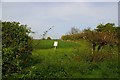
Start of a Walk
This is the start of a permissive footpath with access until 2011 see http://countrywalks.defra.gov.uk/Default.aspx?Module=CountryWalkDetails&Site=3956
This gap in the hedge is not exactly something you would stumble across easily especially as the DEFRA website gives a helpful Grid ref of Image that is not at either end of the walk!
Image: © Glyn Baker
Taken: 3 May 2008
0.21 miles