IMAGES TAKEN NEAR TO
Park Lane, MALDON, CM9 8HB
Introduction
This page details the photographs taken nearby to Park Lane, CM9 8HB by members of the Geograph project.
The Geograph project started in 2005 with the aim of publishing, organising and preserving representative images for every square kilometre of Great Britain, Ireland and the Isle of Man.

There are currently over 7.5m images from over14,400 individuals and you can help contribute to the project by visiting https://www.geograph.org.uk
Image Map
Images are licensed for reuse under creativecommons.org/licenses/by-sa/2.0
Notes
- Clicking on the map will re-center to the selected point.
- The higher the marker number, the further away the image location is from the centre of the postcode.
Image Listing (7 Images Found)
Images are licensed for reuse under creativecommons.org/licenses/by-sa/2.0
Image
Details
Distance
2
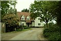
Track near Park Farm
The track was muddy after recent rain, in this section of the path used by farm vehicles.
Image: © Andrew Hill
Taken: 5 Dec 2009
0.14 miles
3
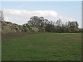
Oxley Meadow - North Field, Tolleshunt Knights
This is the larger northern meadow on this nature reserve, managed by the Essex Wildlife Trust. See http://www.wildessex.net/sites/Oxley%20Meadow.htm
See also: Image]
Image: © Roger Jones
Taken: 28 Apr 2013
0.21 miles
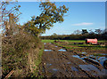
4
Field and line of trees
This is the second field south from the edge of Long Wood as shown on the 1:25,000 map with tree symbols.
Image: © Andrew Hill
Taken: 5 Dec 2009
0.22 miles
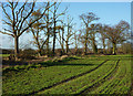
5
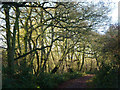
Footpath among trees
Heading along the woodland edge from Park Farm towards Layer Brook and Tiptree.
Image: © Andrew Hill
Taken: 5 Dec 2009
0.24 miles
6
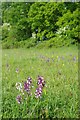
Orchids in Oxley Meaddows
Image: © Glyn Baker
Taken: 7 May 2011
0.24 miles
7
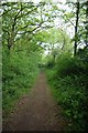
Bridle Path to Tiptree
This Bridle Path connects Park Lane in Tolleshunt Knights with Image
Image: © Glyn Baker
Taken: 7 May 2011
0.24 miles