IMAGES TAKEN NEAR TO
Beckingham Road, MALDON, CM9 8EB
Introduction
This page details the photographs taken nearby to Beckingham Road, CM9 8EB by members of the Geograph project.
The Geograph project started in 2005 with the aim of publishing, organising and preserving representative images for every square kilometre of Great Britain, Ireland and the Isle of Man.

There are currently over 7.5m images from over14,400 individuals and you can help contribute to the project by visiting https://www.geograph.org.uk
Image Map
Images are licensed for reuse under creativecommons.org/licenses/by-sa/2.0
Notes
- Clicking on the map will re-center to the selected point.
- The higher the marker number, the further away the image location is from the centre of the postcode.
Image Listing (6 Images Found)
Images are licensed for reuse under creativecommons.org/licenses/by-sa/2.0
Image
Details
Distance
1
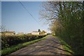
Totham Hill
Looking up hill on Beckingham Rd
Image: © Glyn Baker
Taken: 2 May 2013
0.02 miles
2
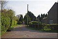
Footpath to Hall Rd
This footpath goes to Hall Road near Great Totham Church
Image: © Glyn Baker
Taken: 2 May 2013
0.03 miles
3
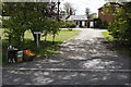
Hill Holme
Hill Holme, a Victorian farmhouse. Once an apple orchard, now an apple juice producer.
Image: © Harry Lane
Taken: 25 Apr 2009
0.11 miles
4
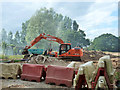
Ground work, Great Totham
This looks like work in connection with Spickets Brook, which passes under the road here in an unobtrusive way. There was a smoky bonfire off to the left, rather fogging things. Note the Nissen hut on the left, one of two on the premises.
Image: © Robin Webster
Taken: 21 Jun 2015
0.14 miles
5
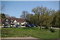
Forester Park Clubhouse
Forester Park Golf & Country Club, The clubhouse is a former barn that dates back to the 16th century it was converted to a residence in the 1930's.
Image: © Glyn Baker
Taken: 2 May 2013
0.18 miles
6
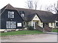
Forrester Park Golf and Tennis Club
The club house is a 16th century building
Image: © Angela Tuff
Taken: 27 Jan 2006
0.23 miles