IMAGES TAKEN NEAR TO
Colchester Road, MALDON, CM9 8DG
Introduction
This page details the photographs taken nearby to Colchester Road, CM9 8DG by members of the Geograph project.
The Geograph project started in 2005 with the aim of publishing, organising and preserving representative images for every square kilometre of Great Britain, Ireland and the Isle of Man.

There are currently over 7.5m images from over14,400 individuals and you can help contribute to the project by visiting https://www.geograph.org.uk
Image Map
Images are licensed for reuse under creativecommons.org/licenses/by-sa/2.0
Notes
- Clicking on the map will re-center to the selected point.
- The higher the marker number, the further away the image location is from the centre of the postcode.
Image Listing (4 Images Found)
Images are licensed for reuse under creativecommons.org/licenses/by-sa/2.0
Image
Details
Distance
1
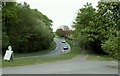
The B1022, looking in the direction of Tiptree
Image: © Robert Edwards
Taken: 25 Apr 2007
0.10 miles
2
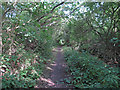
Wooded public footpath, Great Totham
This footpath runs along a stream which is on the boundary of Great Totham and Great Braxted parishes.
Image: © Roger Jones
Taken: 16 Aug 2014
0.13 miles
3
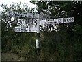
Direction Sign ? Signpost on the B1022 in Great Totham
Located on the west side of the crossroads of the B1022 Maldon Road, Braxted Lane and Mill Road in Great Totham parish. 4 arms and cone finial.
Milestone Society National ID: EX_TL8613
Image: © John V Nicholls
Taken: 22 Jun 2002
0.20 miles
4
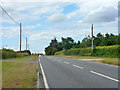
B1022 north of Great Totham
The road from Maldon to Colchester.
Image: © Robin Webster
Taken: 21 Jun 2015
0.23 miles