IMAGES TAKEN NEAR TO
Church Road, MALDON, CM9 8AW
Introduction
This page details the photographs taken nearby to Church Road, CM9 8AW by members of the Geograph project.
The Geograph project started in 2005 with the aim of publishing, organising and preserving representative images for every square kilometre of Great Britain, Ireland and the Isle of Man.

There are currently over 7.5m images from over14,400 individuals and you can help contribute to the project by visiting https://www.geograph.org.uk
Image Map (Loading...)


Getting Data...Please wait
Leaflet Map data © OpenStreetMap
Images are licensed for reuse under creativecommons.org/licenses/by-sa/2.0
Notes
- Clicking on the map will re-center to the selected point.
- The higher the marker number, the further away the image location is from the centre of the postcode.
Image Listing (5 Images Found)
Images are licensed for reuse under creativecommons.org/licenses/by-sa/2.0
Image
Details
Distance
1
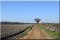
Bridleway off Church Road
A very sandy bridleway leading to Rockleys Farm.
Image: © Trevor Harris
Taken: 6 Feb 2020
0.09 miles
2
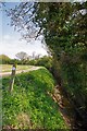
Drain and Bridleway
This country stream is marked on the map as a drain.
Image: © Glyn Baker
Taken: 2 May 2013
0.13 miles
3
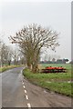
Church Road
Parked disc harrow. Corner Cottage in the distance
Image: © John Myers
Taken: 12 Feb 2013
0.21 miles
4
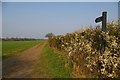
Blackthorn and Bridlepath
This is the bridlepath from Church Road to Rockley’s Farm
Image: © Glyn Baker
Taken: 1 Apr 2007
0.22 miles
5

Church Road, Tolleshunt Major
Heading towards the church.
Image: © Robin Webster
Taken: 6 Dec 2015
0.22 miles