IMAGES TAKEN NEAR TO
Goldhanger, MALDON, CM9 8AL
Introduction
This page details the photographs taken nearby to CM9 8AL by members of the Geograph project.
The Geograph project started in 2005 with the aim of publishing, organising and preserving representative images for every square kilometre of Great Britain, Ireland and the Isle of Man.

There are currently over 7.5m images from over14,400 individuals and you can help contribute to the project by visiting https://www.geograph.org.uk
Image Map (Loading...)


Getting Data...Please wait
Leaflet Map data © OpenStreetMap
Images are licensed for reuse under creativecommons.org/licenses/by-sa/2.0
Notes
- Clicking on the map will re-center to the selected point.
- The higher the marker number, the further away the image location is from the centre of the postcode.
Image Listing (7 Images Found)
Images are licensed for reuse under creativecommons.org/licenses/by-sa/2.0
Image
Details
Distance
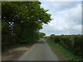
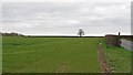
3
Road junction on Maldon Road (B1026)
Junction with Church Road.
Image: © JThomas
Taken: 27 Apr 2017
0.17 miles
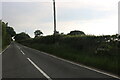
4
The south end of Church Road
The church being that of Tolleshunt Major. Church Road is here a turning off Maldon Road, B1026, on the right.
Image: © Robin Webster
Taken: 6 Dec 2015
0.18 miles
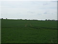
5
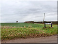
Arable field boundary off Maldon Road, Tolleshunt Major
Image: © Roger Jones
Taken: 6 Apr 2015
0.20 miles
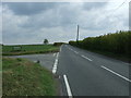
6
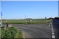
End of Church Road
...where it meets Maldon Road.
Image: © Trevor Harris
Taken: 6 Feb 2020
0.20 miles