IMAGES TAKEN NEAR TO
Centaur Way, MALDON, CM9 6XU
Introduction
This page details the photographs taken nearby to Centaur Way, CM9 6XU by members of the Geograph project.
The Geograph project started in 2005 with the aim of publishing, organising and preserving representative images for every square kilometre of Great Britain, Ireland and the Isle of Man.

There are currently over 7.5m images from over14,400 individuals and you can help contribute to the project by visiting https://www.geograph.org.uk
Image Map (Loading...)


Getting Data...Please wait
Leaflet Map data © OpenStreetMap
Images are licensed for reuse under creativecommons.org/licenses/by-sa/2.0
Notes
- Clicking on the map will re-center to the selected point.
- The higher the marker number, the further away the image location is from the centre of the postcode.
Image Listing (6 Images Found)
Images are licensed for reuse under creativecommons.org/licenses/by-sa/2.0
Image
Details
Distance
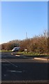
2
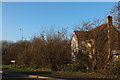
Limebrook Way, Maldon
Lime Brook runs for a couple of miles alongside the main road, and joins with a series of other waterways to the east.
Image: © David Howard
Taken: 23 Feb 2019
0.18 miles
3
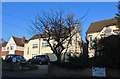
A view of Mariners Way
The main road in front is Limebrook Way. The housing estate was built in the 1990s when Maldon suddenly grew in size.
Image: © Robert Edwards
Taken: 29 Apr 2008
0.18 miles
4
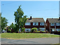
Houses on Wordsworth Avenue
A residential area south of the town centre.
Image: © Robin Webster
Taken: 21 Jun 2014
0.18 miles
6
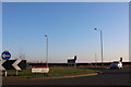
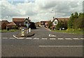
Roundabout on Limebrook Way, Maldon
At the junction of Fambridge Road
Image: © David Howard
Taken: 23 Feb 2019
0.21 miles