IMAGES TAKEN NEAR TO
Bassetts Lane, MALDON, CM9 6RY
Introduction
This page details the photographs taken nearby to Bassetts Lane, CM9 6RY by members of the Geograph project.
The Geograph project started in 2005 with the aim of publishing, organising and preserving representative images for every square kilometre of Great Britain, Ireland and the Isle of Man.

There are currently over 7.5m images from over14,400 individuals and you can help contribute to the project by visiting https://www.geograph.org.uk
Image Map (Loading...)


Getting Data...Please wait
Leaflet Map data © OpenStreetMap
Images are licensed for reuse under creativecommons.org/licenses/by-sa/2.0
Notes
- Clicking on the map will re-center to the selected point.
- The higher the marker number, the further away the image location is from the centre of the postcode.
Image Listing (5 Images Found)
Images are licensed for reuse under creativecommons.org/licenses/by-sa/2.0
Image
Details
Distance
1
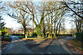
Trees at the junction
Bassetts Lane heads round to the left, West Bowers Road goes right.
Image: © Robin Webster
Taken: 11 Dec 2012
0.04 miles
2
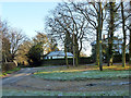
A frosty corner, Woodham Walter
Or it might be Little Baddow.
Image: © Robin Webster
Taken: 11 Dec 2012
0.04 miles
3
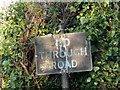
No through road sign
On the turning off Bassetts Lane to Retreat Farm.
Image: © Robin Webster
Taken: 11 Dec 2012
0.16 miles
4
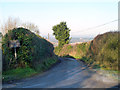
No through road to Retreat Farm
A turning off Bassetts Lane. Note the old road sign.
Image: © Robin Webster
Taken: 11 Dec 2012
0.17 miles
5
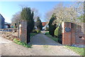
West Bowers Hall
The entrance with the Hall beyond and an entrance to West Bowers Farm beside it.
Image: © Trevor Harris
Taken: 15 Jan 2012
0.23 miles