IMAGES TAKEN NEAR TO
Fambridge Road, MALDON, CM9 6PG
Introduction
This page details the photographs taken nearby to Fambridge Road, CM9 6PG by members of the Geograph project.
The Geograph project started in 2005 with the aim of publishing, organising and preserving representative images for every square kilometre of Great Britain, Ireland and the Isle of Man.

There are currently over 7.5m images from over14,400 individuals and you can help contribute to the project by visiting https://www.geograph.org.uk
Image Map (7 Images)


Getting Data...Please wait
Leaflet Map data © OpenStreetMap
Images are licensed for reuse under creativecommons.org/licenses/by-sa/2.0
Notes
- Clicking on the map will re-center to the selected point.
- The higher the marker number, the further away the image location is from the centre of the postcode.
Image Listing (7 Images Found)
Images are licensed for reuse under creativecommons.org/licenses/by-sa/2.0
Image
Details
Distance
1
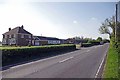
Fambridge Rd at Purleigh Wash Farm
Looking towards Maldon on the B1018.
Image: © Glyn Baker
Taken: 12 May 2016
0.06 miles
3
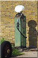
Old Fuel Pump at Purleigh Wash Farm
Across the road from the farmhouse
Image: © Glyn Baker
Taken: 12 May 2016
0.06 miles
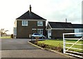
4
Farm Beside the Fambridge Rd
I think this must be part of Purleigh Wash Farm. The farm extends across the road see Image
Image: © Glyn Baker
Taken: 12 May 2016
0.12 miles
5

Simmons Lane at the junction of Baron's Lane
Image: © David Howard
Taken: 7 Dec 2019
0.23 miles
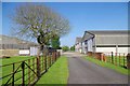
6
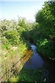
Mundon Wash
This stream eventually discharges into Southey Creek at Image
Image: © Glyn Baker
Taken: 12 May 2016
0.24 miles
7
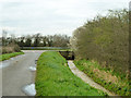
Ditch by Simmonds Lane
Flowing strongly towards a bridge on Barons Lane ahead.
Image: © Robin Webster
Taken: 4 Mar 2014
0.24 miles