IMAGES TAKEN NEAR TO
London Road, MALDON, CM9 6LY
Introduction
This page details the photographs taken nearby to London Road, CM9 6LY by members of the Geograph project.
The Geograph project started in 2005 with the aim of publishing, organising and preserving representative images for every square kilometre of Great Britain, Ireland and the Isle of Man.

There are currently over 7.5m images from over14,400 individuals and you can help contribute to the project by visiting https://www.geograph.org.uk
Image Map (Loading...)


Getting Data...Please wait
Leaflet Map data © OpenStreetMap
Images are licensed for reuse under creativecommons.org/licenses/by-sa/2.0
Notes
- Clicking on the map will re-center to the selected point.
- The higher the marker number, the further away the image location is from the centre of the postcode.
Image Listing (7 Images Found)
Images are licensed for reuse under creativecommons.org/licenses/by-sa/2.0
Image
Details
Distance
1

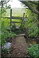
Footpath to Curling Tye Green
Glyphosate shows the way.
Image: © Glyn Baker
Taken: 6 May 2016
0.10 miles
3

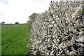
Iconic Tree on Curve in Road, Beeleigh
Prominent tree, near footpath marker on curve, London Road, nr Beeleigh farms
Image: © Roger Jones
Taken: 21 May 2011
0.12 miles
4

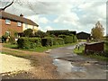
Beeleigh Lodge, Maldon
Large house on London Road neighbouring Brook Farm.
Image: © John Myers
Taken: 1 Sep 2006
0.15 miles
6

Farm track leading to Great Beeleigh Farm
Image: © Robert Edwards
Taken: 29 Apr 2008
0.19 miles
7
The Path to Manor Rd
This path runs between Abbey Turning & Manor Rd
Image: © Glyn Baker
Taken: 6 May 2016
0.21 miles