IMAGES TAKEN NEAR TO
Cumberland Avenue, MALDON, CM9 6JT
Introduction
This page details the photographs taken nearby to Cumberland Avenue, CM9 6JT by members of the Geograph project.
The Geograph project started in 2005 with the aim of publishing, organising and preserving representative images for every square kilometre of Great Britain, Ireland and the Isle of Man.

There are currently over 7.5m images from over14,400 individuals and you can help contribute to the project by visiting https://www.geograph.org.uk
Image Map
Images are licensed for reuse under creativecommons.org/licenses/by-sa/2.0
Notes
- Clicking on the map will re-center to the selected point.
- The higher the marker number, the further away the image location is from the centre of the postcode.
Image Listing (5 Images Found)
Images are licensed for reuse under creativecommons.org/licenses/by-sa/2.0
Image
Details
Distance
2
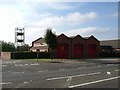
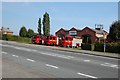
Maldon Fire Station
A Modern Building on the outskirts of Town
Image: © Glyn Baker
Taken: 20 Aug 2005
0.20 miles
5
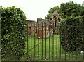
The ruins of St. Giles Leper Hospital
It is said that the hospital was founded by Henry II. All that survives is part of the transepts and chancel of a chapel that date from the end of the 12th century. Although the gates were padlocked, it is open to the public at certain times of the year. This is the view from Spital Road.
Image: © Robert Edwards
Taken: 4 Jun 2008
0.23 miles