IMAGES TAKEN NEAR TO
Ware View Terrace, Spital Road, MALDON, CM9 6GD
Introduction
This page details the photographs taken nearby to Ware View Terrace, Spital Road, CM9 6GD by members of the Geograph project.
The Geograph project started in 2005 with the aim of publishing, organising and preserving representative images for every square kilometre of Great Britain, Ireland and the Isle of Man.

There are currently over 7.5m images from over14,400 individuals and you can help contribute to the project by visiting https://www.geograph.org.uk
Image Map (Loading...)


Getting Data...Please wait
Leaflet Map data © OpenStreetMap
Images are licensed for reuse under creativecommons.org/licenses/by-sa/2.0
Notes
- Clicking on the map will re-center to the selected point.
- The higher the marker number, the further away the image location is from the centre of the postcode.
Image Listing (142 Images Found)
Images are licensed for reuse under creativecommons.org/licenses/by-sa/2.0
Image
Details
Distance
1
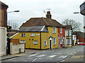
1 - 5 (odds) Fambridge Road, Maldon
A block of three cottages in yellow and red brick, whose appearance as a unit is not helped by paint on part of number 5. This originally had a front door like the others, but mirrored. This has been bricked up and a side door substituted.
Image: © Robin Webster
Taken: 4 Mar 2014
0.03 miles
2
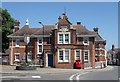
7 and 9 Fambridge Road, Maldon
A grade II listed building from the 17th century, altered and extended later.
Image: © Robin Webster
Taken: 4 Mar 2014
0.03 miles
4
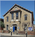
St. Peter's Hospital chapel in Spital Road
The hospital was originally built as a workhouse in 1873. This chapel may be of the same age.
Image: © Robert Edwards
Taken: 7 May 2008
0.06 miles
7
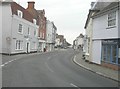
Looking east along the High Street
From its junction with Coach Lane.
Image: © John Baker
Taken: 31 Mar 2014
0.09 miles
8
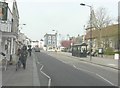
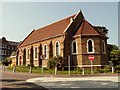
Looking west along the High Street
On the right is the south wall of the Church of All Saints, which is located at 2, Silver Street. It is a grade I listed building dating from between the 13th and 15th centuries. It was remodelled in 1728 and underwent restoration in 1858, 1867 and 1877 http://www.britishlistedbuildings.co.uk/en-464532-church-of-all-saints-maldon-essex
Image: © John Baker
Taken: 3 Apr 2014
0.09 miles
10
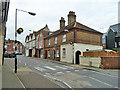
The White Horse, Maldon
A Shepherd Neame house. In former times the beer would have come via sailing barge direct from the brewery at Faversham, rather than a very tedious land route. There is a through way to a yard at the rear, but vehicle access to this, used as its car park, is nowadays from White Horse Lane at the rear. A grade II listed building (including the 'Naked Flame' shop to the left) from the late 16th and early 19th centuries.
Image: © Robin Webster
Taken: 4 Mar 2014
0.09 miles