IMAGES TAKEN NEAR TO
Tait Mews, MALDON, CM9 5LE
Introduction
This page details the photographs taken nearby to Tait Mews, CM9 5LE by members of the Geograph project.
The Geograph project started in 2005 with the aim of publishing, organising and preserving representative images for every square kilometre of Great Britain, Ireland and the Isle of Man.

There are currently over 7.5m images from over14,400 individuals and you can help contribute to the project by visiting https://www.geograph.org.uk
Image Map (Loading...)


Getting Data...Please wait
Leaflet Map data © OpenStreetMap
Images are licensed for reuse under creativecommons.org/licenses/by-sa/2.0
Notes
- Clicking on the map will re-center to the selected point.
- The higher the marker number, the further away the image location is from the centre of the postcode.
Image Listing (348 Images Found)
Images are licensed for reuse under creativecommons.org/licenses/by-sa/2.0
Image
Details
Distance
4
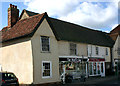
140-44 High Street, Maldon
Maldon is one of those places where antique buildings have been adapted to accommodate present-day commercial requirements instead of being demolished. In this case a building of 'hall' construction dating from before 1550 houses several businesses.
Image: © David Kemp
Taken: 5 Mar 2019
0.03 miles

10
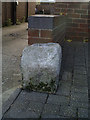
Old Milestone by Embassy Court, High Street, Maldon
Carved stone post by the UC road, in parish of MALDON (MALDON District), Embassy Court, in pavement by entrance, on South side of road. Erected by the Chelmsford (Division of Essex First District) turnpike trust in the 19th century.
Inscription unknown
Milestone Society National ID: EX_MGMN38.
Image: © JV Nicholls
Taken: 25 Feb 2011
0.03 miles